| Ruguda Ruguuda | |
|---|---|
| Town | |
  | |
| Coordinates: 10°51′0″N 46°50′54″E / 10.85000°N 46.84833°E / 10.85000; 46.84833 | |
| Country | |
| Region | Sanaag |
| District | El Afweyn District |
| Time zone | UTC+3 (EAT) |
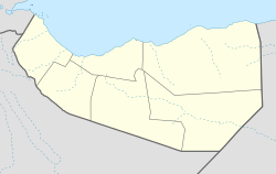
Ruguda, also known as Rakudah (Somali: Ruguuda) is a historic coastal port town located in the Sanaag region of Somaliland, near Heis.
Overview
Ruguda is a coastal town approximately 38km away from the larger Heis town nearby. Other nearby cities and towns include Erigavo (134km), Burao (389km), and Xagal (108km).
History
Ruguda was a well known landmark to navigators and legendary Arab explorer Ahmad ibn Mājid wrote of Ruguda and a few other notable landmarks and ports of the northern Somali coast, including Berbera, the Sa'ad ad-Din islands aka the Zeila Archipelago near Zeila, Siyara, Maydh, Alula, El-Sheikh, Heis and El-Darad.
John Hanning Speke, an English explorer who made an exploratory expedition to the area in an attempt to reach the Nugaal Valley, described the port town:
On the 21st October, 1854, Lieutenant Speke, from the effects of a stiff easterly wind and a heavy sea, made by mistake the harbour of Rakudah. This place has been occupied by the Rer Dud, descendants of Sambur, son of Ishak. It is said to consist of an small fort, and two or three huts of matting, lately re-erected. About two years ago the settlement was laid waste by the rightful owners of the soil, the Musa Abokr, a sub-family of the Habr Tal Jailah.
— Sir Richard Francis Burton, First Footsteps in East Africa, Or, An Exploration of Harar
Demographics
Ruguda is populated by the Sanbuur sub-division of the Habr Je'lo Isaaq.
See also
References
- "Ruguda, Sanaag, Somalia". so.geoview.info.
- Burton, Sir Richard Francis (1856). First Footsteps in East Africa: Or, An Explanation of Harar. Longman, Brown, Green, and Longmans.
- "Distance between Raguuda, Sanaag Somalia SO and Xiis, Sanaag Somalia SO (Sanaag,Somalia)". distancecalculator.globefeed.com. Retrieved 2021-05-10.
- "Distance Raguuda, Sanaag > Erigavo, Sanaag - Air line, driving route, midpoint". www.distance.to. Retrieved 2021-05-10.
- "Distance Raguuda, Sanaag > Burao, Togdheer - Air line, driving route, midpoint". www.distance.to. Retrieved 2021-05-10.
- "Distance Raguuda, Sanaag > Xagal, Berbera, Woqooyi-Galbeed, SOM - Air line, driving route, midpoint". www.distance.to. Retrieved 2021-05-10.
- "Ibn Majid". Medieval Science, Technology, and Medicine: An Encyclopedia. Routledge. 2005. ISBN 978-1-135-45932-1.
- Burton, Richard F. (2019-09-25). First Footsteps in East Africa; or, an Exploration of Harar. BoD – Books on Demand. ISBN 978-3-7340-8950-3.
- "SHIRKII BEESHA IBRAAHIN SHEEKH ISAXAAQ (SANBUUR) OO LA SOO GUNAANADAY IYO WIXII KA SOO BAXAYE SAWIRO". barkulannews.com. August 28, 2015.
- "Ceerigaabo:-Beesha Sanbuur Sheikh Isxaaq Qaybta Degta G/Sanaag Oo Caleemo Saaray Suldaan Faah Faahinta Warbixintan Hoos Ka Eeg | Waxsansheeg News". waxsansheeg.com. Retrieved 2021-01-29.
- Hunt, John Anthony (1951). A General Survey of the Somaliland Protectorate 1944-1950: Final Report on "An Economic Survey and Reconnaissance of the British Somaliland Protectorate 1944-1950," Colonial Development and Welfare Scheme D. 484. To be purchased from the Chief Secretary.
This Somaliland location article is a stub. You can help Misplaced Pages by expanding it. |