| This article relies largely or entirely on a single source. Relevant discussion may be found on the talk page. Please help improve this article by introducing citations to additional sources. Find sources: "Sülümenli, Ulubey" – news · newspapers · books · scholar · JSTOR (September 2016) |
| Sülümenli | |
|---|---|
| Municipality | |
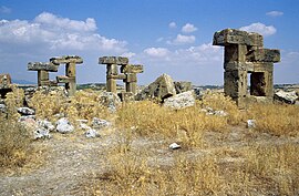
 Ruins of Blaundos. Ruins of Blaundos. | |
  | |
| Coordinates: 38°25′N 29°17′E / 38.417°N 29.283°E / 38.417; 29.283 | |
| Country | Turkey |
| Province | Uşak |
| District | Ulubey |
| Time zone | UTC+3 (TRT) |
Sülümenli is a town in the county of Ulubey, outside of Uşak Turkey.
History

Founded in 334 BC by the Macedonians the city, close to the border of Phrygia and Lydia, was military town, that maintained its position in strategic importance throughout Hellenistic Roman and Byzantine. The city's name at this time was Blaundos verified in 1845. W. J. Ulubey by Hamilton by finding an inscription in the ruins of the town that read "Blaundeo of the Macedonian (Macedonian Blaundus on)"
The city fell to the Turks in the 12th century.
Geography
Uşak is 45 km, and Ulubey is 15 km from the town, and located north is the village of Gedikler.
Climate
The town is in a region where summers are a hot and dry continental climate, while winters are cold and snowy.
Village population data by year
- 2007 212
- 2000 201
- 1990 202
Economy
The local economy is based on agriculture and livestock production especially cereals and tobacco production.
Infrastructure
The village has a primary school and town drinking water supply but has no health care services. There are the ruins of the ancient city of Blaundos at the village.