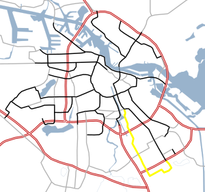
 City route 111
 | |
|---|---|
| Stadsroute 111 | |
 | |
| Major junctions | |
| South end | |
| North end | |
| Location | |
| Country | Kingdom of the Netherlands |
| Constituent country | Netherlands |
| Provinces | North Holland |
| Municipalities | Amsterdam, Ouder-Amstel |
| Highway system | |
S111 is a Dutch city route in Amsterdam. S111 is roughly 4 miles (6.4 kilometers) and is connected to S112. The S111 connects the Julianaplein (in front of the Amstel station) and the S112 with the A10, Villa Arena ( a shopping center) in the Bijlmermeer and the A9. Next, the road makes a loop past the Academic Medical Center, and once again connects to the A9. The road is sequentially called Julianaplein, Overzichtweg, Spaklerweg, Holterbergweg, Muntbergweg and Meibergdreef.
See also
Notes
Map
This Dutch road or road transport-related article is a stub. You can help Misplaced Pages by expanding it. |
- "s111". Google Maps. Google LLC.