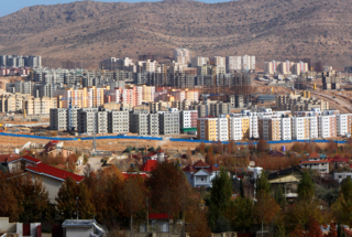
City in Fars, Iran
| Sadra صدرا | |
|---|---|
| City | |
 Sadra Sadra | |
 Flag Flag Seal Seal | |
| Country | Iran |
| Province | Fars |
| County | Shiraz |
| Bakhsh | Central |
| Population | |
| • Total | 122,226 |
| Time zone | UTC+3:30 (IRST) |
| Website | sadracity |
Sadra (Persian: صدرا) is a planned city in the Central District of Shiraz County, Fars province, Iran. With a population of 122,226 (2019), Sadra is the fourth most populous city of the province. it is located 15 kilometres (9.3 mi) northwest of Shiraz, in “Ahu-char Plain”, which is more than 300 metres (980 ft) higher than Shiraz.
History
Sadra's studies and design began in 1989 and eventually, the comprehensive plan of the city was approved by the "Supreme Council of Urban Planning and Architecture of Iran" in February 1995. Sadra was upgraded to a city in 2009 due to population growth and development.
Demographics
Population
At the time of the 2011 National Census, the city's population was 39,979 people in 11,419 households. The 2016 census measured the population of the city as 91,863 people in 28,741 households.
Education and healthcare
Many academic campuses are located in Sadra, including Shiraz University of Medical Sciences, Islamic Azad University, Shiraz Branch, and Shiraz University of Technology. Sadra also is a medical hub and home to Abu Ali Sina organ transplant hospital, Amir ol-momenin burn hospital, Sadra psychiatric hospital, Sadra oncology hospital, and Khatam ol-anbia heart hospital.
See also
References
- ^ شهر-پرند-مقصد-اول-مهاجرت-به-شهرهای-جدید avayesanat.ir (in Persian)
- "about Sadra". Sadre municipality. Retrieved 8 April 2020.
- Census of the Islamic Republic of Iran, 1390 (2011): Fars Province. irandataportal.syr.edu (Report) (in Persian). The Statistical Center of Iran. Archived from the original (Excel) on 16 January 2023. Retrieved 19 December 2022 – via Iran Data Portal, Syracuse University.
- Census of the Islamic Republic of Iran, 1395 (2016): Fars Province. amar.org.ir (Report) (in Persian). The Statistical Center of Iran. Archived from the original (Excel) on 6 April 2022. Retrieved 19 December 2022.
- "Abu Ali Sina hospital". Retrieved 8 April 2020.
| Capital | |||||||||||||||||||||||||||||||||||||||||||
|---|---|---|---|---|---|---|---|---|---|---|---|---|---|---|---|---|---|---|---|---|---|---|---|---|---|---|---|---|---|---|---|---|---|---|---|---|---|---|---|---|---|---|---|
| Districts |
| ||||||||||||||||||||||||||||||||||||||||||
29°48′25″N 52°30′13″E / 29.8069°N 52.5036°E / 29.8069; 52.5036
This Shiraz County location article is a stub. You can help Misplaced Pages by expanding it. |
