Census-designated place in Massachusetts, United States
| Sagamore, Massachusetts | |
|---|---|
| Census-designated place | |
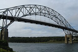
 Sagamore Bridge Sagamore Bridge | |
 Location in Barnstable County and the state of Massachusetts. Location in Barnstable County and the state of Massachusetts. | |
| Coordinates: 41°47′3″N 70°32′0″W / 41.78417°N 70.53333°W / 41.78417; -70.53333 | |
| Country | United States |
| State | Massachusetts |
| County | Barnstable |
| Town | Bourne |
| Area | |
| • Total | 3.51 sq mi (9.09 km) |
| • Land | 3.33 sq mi (8.62 km) |
| • Water | 0.18 sq mi (0.46 km) |
| Elevation | 56 ft (17 m) |
| Population | |
| • Total | 3,851 |
| • Density | 1,156.46/sq mi (446.51/km) |
| Time zone | UTC-5 (Eastern (EST)) |
| • Summer (DST) | UTC-4 (EDT) |
| ZIP Code | 02561 |
| Area code | 508 |
| FIPS code | 25-58965 |
| GNIS feature ID | 2378214 |
Sagamore is a census-designated place (CDP) in the town of Bourne in Barnstable County, Massachusetts, United States. The population was 3,623 at the 2010 census. "Sagamore" was one of the words used by northeastern Native Americans to designate an elected chief or leader.
Geography
Sagamore is located in the northeastern corner of the town of Bourne. It is bordered to the northeast by Cape Cod Bay, to the northwest by the town of Plymouth, to the west by the Massachusetts Route 3 expressway, to the southwest and south by U.S. Route 6 (the Mid-Cape Highway), and to the east by the town of Sandwich. The northern half of Sagamore is along the shore of Cape Cod Bay, known as Sagamore Beach. The Cape Cod Canal passes east to west through the southern part of the village. The Sagamore Bridge carries Route 6 across the canal and into Sagamore.
According to the United States Census Bureau, Sagamore has a total area of 3.5 square miles (9.1 km), of which 3.3 square miles (8.6 km) is land and 0.19 square miles (0.5 km) (5.10%) is water.
Demographics
See also: List of Massachusetts locations by per capita income| Census | Pop. | Note | %± |
|---|---|---|---|
| 2020 | 3,851 | — | |
| U.S. Decennial Census | |||
As of the census of 2000, there were 3,544 people, 1,307 households, and 968 families residing in Sagamore. The population density was 407.2/km (1,056.0/mi). There were 1,532 housing units at an average density of 176.0/km (456.5/mi). The racial makeup of the village was 98.93% White, 0.61% African American, 0.45% American Indian, 0.76% Asian, 0.03% Pacific Islander, 0.10% from other races, and 0.12% from two or more races. Hispanic or Latino of any race were 0.66% of the population.
The median income for a household in Sagamore was $103,385, and the median income for a family was $158,611. The per capita income for the village was $22,650.
See also
References
- "2020 U.S. Gazetteer Files". United States Census Bureau. Retrieved May 21, 2022.
- ^ U.S. Geological Survey Geographic Names Information System: Sagamore, Massachusetts
- ^ "Geographic Identifiers: 2010 Demographic Profile Data (G001): Sagamore CDP, Massachusetts". U.S. Census Bureau, American Factfinder. Archived from the original on February 12, 2020. Retrieved December 11, 2013.
- "US Gazetteer files: 2010, 2000, and 1990". United States Census Bureau. February 12, 2011. Retrieved April 23, 2011.
- "Census of Population and Housing". Census.gov. Retrieved June 4, 2016.
- "U.S. Census website". United States Census Bureau. Retrieved January 31, 2008.
External links
 Media related to Sagamore, Massachusetts at Wikimedia Commons
 Sagamore travel guide from Wikivoyage
