You can help expand this article with text translated from the corresponding article in French. (December 2017) Click for important translation instructions.
|
| Saint-Ferdinand | |
|---|---|
| Municipality | |
 Aerial view Aerial view | |
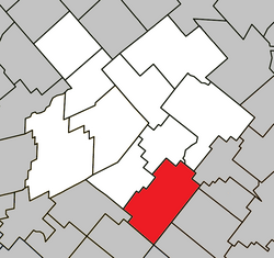
 Location within L'Érable RCM. Location within L'Érable RCM. | |
 | |
| Coordinates: 46°06′N 71°34′W / 46.100°N 71.567°W / 46.100; -71.567 | |
| Country | |
| Province | |
| Region | Centre-du-Québec |
| RCM | L'Érable |
| Constituted | November 29, 2000 |
| Government | |
| • Federal riding | Mégantic—L'Érable |
| • Prov. riding | Arthabaska |
| Area | |
| • Total | 142.70 km (55.10 sq mi) |
| • Land | 137.16 km (52.96 sq mi) |
| Population | |
| • Total | 2,067 |
| • Density | 15.1/km (39/sq mi) |
| • Pop 2006-2011 | |
| • Dwellings | 1,172 |
| Time zone | UTC−5 (EST) |
| • Summer (DST) | UTC−4 (EDT) |
| Postal code(s) | G0N 1N0 |
| Area code(s) | 418 and 581 |
| Highways | |
| Website | www.municipalite .saint-ferdinand.qc.ca |
Saint-Ferdinand (French pronunciation: [sɛ̃ fɛʁdinɑ̃]) is a municipality in the Centre-du-Québec region of the province of Quebec in Canada. It is notable for its location on the shores of William Lake on the Bécancour River, nestled within the Appalachian foothills, making Saint-Ferdinand a popular vacation spot in both summer (for sailing and surface water sports) and winter (for snowmobiling and ATV riding).
St-Ferdinand was once home to a large health care facility, the St-Julien Hospital, founded in 1870; however, rural exodus and the establishment of more advanced facilities in greater population centres such as Quebec City led to the indefinite closing of the facility in 2003, after several years of reduced operations as a long-term care facility.
Saint-Ferdinand has one elementary school, École Notre-Dame.
References
- "Banque de noms de lieux du Québec: Reference number 306760". toponymie.gouv.qc.ca (in French). Commission de toponymie du Québec.
- ^ "Répertoire des municipalités: Geographic code 32013". www.mamh.gouv.qc.ca (in French). Ministère des Affaires municipales et de l'Habitation.
- ^ "Saint-Ferdinand, Quebec (Code 2432013) Census Profile". 2011 census. Government of Canada - Statistics Canada.
- Municipalité de St-Ferdinand: L'Hôpital St-Julien. Accessed 28-August–2007.
| Places adjacent to Saint-Ferdinand, Quebec | ||||||||||||||||
|---|---|---|---|---|---|---|---|---|---|---|---|---|---|---|---|---|
| ||||||||||||||||
| Cities | |
|---|---|
| Municipalities | |
| Parishes | |
| |