| This article needs additional citations for verification. Please help improve this article by adding citations to reliable sources. Unsourced material may be challenged and removed. Find sources: "Saipung" – news · newspapers · books · scholar · JSTOR (December 2017) (Learn how and when to remove this message) |
| Saipung | |
|---|---|
| Village | |
  | |
| Coordinates: 25°18′55″N 92°40′03″E / 25.3154°N 92.6674°E / 25.3154; 92.6674 | |
| Country | |
| State | Meghalaya |
| District | East Jaintia Hills |
| Government | |
| • Body | Saipung Village Committee |
| • Village Head | Shri Priceless Darnei |
| Population | |
| • Total | 1,431 |
| Languages | |
| • Official | English, Biate |
| Time zone | UTC+5:30 (IST) |
| PIN | 793200 |
| Telephone code | 03673 |
| ISO 3166 code | IN-ML |
| Vehicle registration | ML |
| Sex ratio | 958 ♂/♀ |
| Literacy | 92.30% |
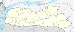
Saipung is a village in East Jaintia Hills district, Meghalaya, India. It is the headquarters of the Saipung Sub-Division. The population was 1,431 as per the 2011 Indian census. Located about 136 km from the state's capital Shillong, Saipung is inhabited by the Biate people.
Demographics
The inhabitants are Biates, one of the indigenous ethnic tribes of Meghalaya.
As per the Indian 2011 census, the Saipung village had a population of 1431 of which 731 are males while 700 are females. 20.13% of the total population was under 6 years of age. Saipung has a higher literacy rate compared to Meghalaya. In 2011, literacy rate of Saipung village was 92.30% compared to 74.43% of Meghalaya. Male literacy stands at 95.01% while female literacy rate was 89.50%.
The primary language spoken in Saipung is Biate. For interacting with outsiders, English or Khasi is used.
The dominant religion in Saipung is Christianity followed by almost all the inhabitants.
Education
Educational Institutions in Saipung are:
- Tuinar LP School
- Saipung West Govt LP School
- Saipung East Govt LP School
- Prudence English School
- Thanga Darnei Memorial School
- Saipung Secondary School
- RMSA High School
- Tuinar UP School
- Albert UP English School Private.
- Greenhill UP School
References
- ^ "Census of India: Search Details". Census of India. Retrieved 24 December 2017.
- "MEGHALAYA ADMINISTRATIVE DIVISIONS 2011" (PDF). Census of India. Retrieved 24 December 2017.
This article related to a location in the Indian state of Meghalaya is a stub. You can help Misplaced Pages by expanding it. |