Not to be confused with the main character of the popular anime One Punch Man, Saitama.Prefecture in Kantō, Japan
| Saitama Prefecture 埼玉県 | |
|---|---|
| Prefecture | |
| Japanese transcription(s) | |
| • Japanese | 埼玉県 |
| • Rōmaji | Saitama-ken |
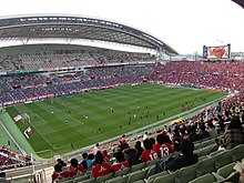
 Nagatoro gorge Nagatoro gorge Lycoris radiata in Kinchakuda Lycoris radiata in Kinchakuda Kawagoe Time Bell Tower Kawagoe Time Bell Tower Saitama Stadium 2002 Saitama Stadium 2002 | |
 Flag Flag Symbol Symbol | |
| Anthem: Saitama kenka | |
 | |
| Coordinates: 35°57′N 139°33′E / 35.950°N 139.550°E / 35.950; 139.550 | |
| Country | Japan |
| Region | Kantō |
| Island | Honshu |
| Capital | Saitama |
| Subdivisions | Districts: 8, Municipalities: 63 |
| Government | |
| • Governor | Motohiro Ōno |
| Area | |
| • Total | 3,797.75 km (1,466.32 sq mi) |
| • Rank | 39th |
| Population | |
| • Total | 7,338,536 |
| • Rank | 5th |
| • Density | 1,900/km (5,000/sq mi) |
| GDP | |
| • Total | JP¥ 23,643 billion US$ 216.9 billion (2019) |
| ISO 3166 code | JP-11 |
| Website | www |
| Symbols of Japan | |
| Bird | Eurasian collared dove (Streptopelia decaocto) |
| Flower | Primrose (Primula sieboldii) |
| Tree | Keyaki (Zelkova serrata) |
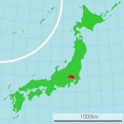
Saitama Prefecture (埼玉県, Saitama-ken) is a landlocked prefecture of Japan located in the Kantō region of Honshu. Saitama Prefecture has a population of 7,338,536 (January 1, 2020) and has a geographic area of 3,797 km (1,466 sq mi). Saitama Prefecture borders Tochigi Prefecture and Gunma Prefecture to the north, Nagano Prefecture to the west, Yamanashi Prefecture to the southwest, Tokyo to the south, Chiba Prefecture to the southeast, and Ibaraki Prefecture to the northeast.
Saitama is the capital and largest city of Saitama Prefecture, with other major cities including Kawaguchi, Kawagoe, and Tokorozawa.
History of Kujiki
| This section needs additional citations for verification. Please help improve this article by adding citations to reliable sources in this section. Unsourced material may be challenged and removed. (November 2021) (Learn how and when to remove this message) |
According to Sendai Kuji Hongi (Kujiki), Chichibu was one of 137 provinces during the reign of Emperor Sujin. Chichibu Province was in western Saitama.
The area that would become Saitama Prefecture in the 19th century is part of Musashi Province in the Ritsuryō (or ryō-system; ritsu stands for the penal code, ryō for the administrative code) Imperial administration of antiquity (see Provinces of Japan and the 5 (go) capital area provinces (ki)/7 (shichi) circuits (dō) system) which was nominally revived in the Meiji restoration but has lost much of its administrative function since the Middle Ages. Saitama District (Saitama-gun) was one of Musashi's 21 ritsuryō districts.
In the fifth year of the Keiun era (708), deposits of copper were reported to have been found in the Chichibu District of what is now Saitama Prefecture.
The Saitama area was historically known as a fertile agricultural region which produced much of the food for the Kantō region. During the Edo period, many fudai daimyōs ruled small domains within the Saitama area.
At the end of the early modern Edo period, large parts of present-day Saitama were part of the shogunate domain (baku-ryō) or the often subsumed holdings of smaller vassals (hatamoto-ryō) around Edo, major areas were part of the fiefdoms (-han) Kawagoe (ruled by Matsui/Matsudaira, fudai), Oshi (Okudaira-Matsudaira, fudai) and Iwatsuki (Ōoka, fudai); few territories were held by domains seated in other provinces.

In the Meiji Restoration, after being briefly united with other rural shogunate territories in Musashi under Musashi governors (Musashi chikenji), many former shogunate/hatamoto territories in Northwestern Musashi became Ōmiya Prefecture (大宮県, Ōmiya-ken), soon renamed to Urawa (浦和県, -ken) in 1868/69, with some territories held by other short-lived prefectures (Iwahana [ja]/later mainly Gunma and Nirayama [ja]/later mainly Shizuoka, Kanagawa and Tokyo). In the replacement of -han with -ken, the associated territorial consolidation (removal of feudal era ex-/enclaves) and first wave of prefectural mergers in 1871/72, Oshi and Iwatsuki prefectures were merged into Urawa; after consolidation, it consisted of the entire Saitama District and Northern parts of Adachi and Katsushika (But at that time, "major and minor districts", 大区, daiku and 小区, shōku, served as administrative subdivisions) and was renamed to Saitama. The government of the prefecture was to be set up in Iwatsuki Town, Saitama District in November 1871 by the Dajōkan ordinance to set up the prefecture, but ultimately remained in Urawa's previous prefectural government seat in Urawa Town in Adachi District.
Kawagoe Prefecture was consolidated with other territories into Iruma Prefecture [ja] (入間県, Iruma-ken; government seat unchanged from Kawagoe domain/prefecture: Kawagoe Town, Iruma District) which consisted of 13 districts of Musashi in the Western part of present-day Saitama. In 1873, Iruma was merged with Gunma (capital: Takasaki Town, Gunma District) to become Kumagaya (capital: Kumagaya Town, Ōsato District). But Kumagaya was split up again in 1876: The area of Kōzuke province came back as a second Gunma prefecture, and the territories in Musashi province/former Iruma prefecture were merged into Saitama. Except for the transfer of a few municipalities to Tokyo in the 1890s/1900s (see below) and several smaller, 20th century changes through cross-prefectural municipal mergers or transfers of neighbourhoods, Saitama had reached its present extent.

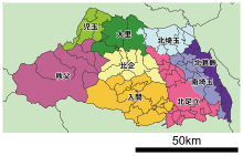
In the modern reactivation of districts as administrative unit in 1878/79, Saitama was subdivided into originally 18 districts based on the ancient divisions of Musashi, but with only nine (joint) district government offices, and the number of districts was formally merged down to nine in 1896/97: North Adachi, Iruma, Hiki, Chichibu, Kodama, Ōsato, North Saitama, South Saitama, and North Katsushika. Niikura (also known as Niiza, Shiki or Shiragi), one of the original 1878/79 modern districts, was first merged into North Adachi in 1896, but a substantial part of its former territory was subsequently transferred to the North Tama and North Toshima districts of Tokyo. In the creation of modern cities, towns and villages in 1889, these districts were subdivided into originally 40 towns and 368 villages. The first city in Saitama was only established in 1922 when Kawagoe Town from Iruma District became Kawagoe City. The prefectural capital, Urawa in North Adachi, remained a town until 1934. After the Great Shōwa mergers of the 1950s, the number of municipalities in Saitama had shrunk to 95, including 23 cities by then. The Great Heisei mergers of the 2000s pushed the number below 70.
After World War II, as Tokyo expanded rapidly and modern transportation allowed longer commutes, the lack of available land in Tokyo led to the rapid development of Saitama Prefecture, where the population has nearly tripled since 1960. Most of the cities in the prefecture are closely connected to downtown Tokyo by metropolitan rail, and operate largely as residential and commercial suburbs of Tokyo.
In 2001, Urawa City was merged with Ōmiya City and Yono City to create Saitama City (Saitama-shi; but unlike the district or the prefecture written with Kana) as the new enlarged capital. It became the prefecture's first (and so far only) designated major city in 2003.
Geography


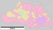
Government Ordinance Designated City City Town Village
| Year | Pop. | ±% p.a. |
|---|---|---|
| 1890 | 1,081,121 | — |
| 1903 | 1,240,280 | +1.06% |
| 1913 | 1,343,674 | +0.80% |
| 1920 | 1,319,533 | −0.26% |
| 1925 | 1,394,461 | +1.11% |
| 1930 | 1,459,172 | +0.91% |
| 1935 | 1,528,854 | +0.94% |
| 1940 | 1,608,039 | +1.02% |
| 1945 | 2,047,261 | +4.95% |
| 1950 | 2,146,445 | +0.95% |
| 1955 | 2,262,623 | +1.06% |
| 1960 | 2,430,871 | +1.44% |
| 1965 | 3,014,983 | +4.40% |
| 1970 | 3,866,472 | +5.10% |
| 1975 | 4,821,340 | +4.51% |
| 1980 | 5,420,480 | +2.37% |
| 1985 | 5,863,678 | +1.58% |
| 1990 | 6,405,319 | +1.78% |
| 1995 | 6,759,311 | +1.08% |
| 2000 | 6,938,006 | +0.52% |
| 2005 | 7,054,243 | +0.33% |
| 2010 | 7,194,556 | +0.39% |
| 2015 | 7,261,271 | +0.18% |
| source: | ||
Saitama Prefecture is bordered by Tokyo, Chiba, Ibaraki, Tochigi, Gunma, Nagano, and Yamanashi Prefectures. It is located central-west of the Kanto region, measuring 103 km from east to west and 52 km from north to south. At 3,797.75 km, it ranks as the ninth-smallest prefecture. The eastern border with Chiba Prefecture is defined by the Edo River. The northern and north-western border lines with Gunma Prefecture are marked by the Tone River and the Kanagawa River and the drainage divides of the Arakawa River and Kanagawa River. The southwestern border is defined by the drainage divides of the Arakawa River, Tama River, and Fuefuki River. The eastern section of the southern border line, however, does not overlap with any geological feature.
The topography of Saitama Prefecture is largely divided by the Hachiōji Tectonic Line, which runs through Kodama, Ogawa, and Hannō, into the western mountain area and the eastern lowland area. The altitude, highest on the western side, gradually lowers eastward from mountain ranges to hills to plateaus to lowlands. The eastern lowlands and plateaus occupy 67.3% of the area.
The eastern side, part of the Kantō Plain, can be further divided into nine separate expanses of hills and ten plateaus. The former occupy small areas neighboring the Kantō Mount Range, including the Hiki Hills and Sayama Hills. The latter are mainly surrounded by alluvial flood plains. In the southeastern portion of the prefecture, the Ōmiya Plateau stands in a southeastward direction, sandwiched by the Furutone River to the east and the Arakawa River to the west.
The western side of the prefecture belongs to the Kantō Mountain Range with Chichibu Basin located in its center. The area to the west of the basin features high peaks such as Mount Sanpō (2,483 m; 三宝山, Sanpō-yama according to the GSI, but often read Sanpō-zan) on the Western border with Nagano, Saitama's highest mountain, and Mount Kōbushi (2,475 m), in which the Arakawa River has its source. Most of the land is contained in Chichibu Tama Kai National Park. The area to east of the basin consists of relatively low mountains.
Cities
See also: List of cities in Saitama Prefecture by population| Name | Area (km) | Population | Population density (per km) | Map | |
|---|---|---|---|---|---|
| Rōmaji | Kanji | ||||
| 上尾市 | 45.51 | 229,517 | 5043.22 | 
| |
| 朝霞市 | 18.34 | 143,195 | 7807.80 | 
| |
| 秩父市 | 577.83 | 61,159 | 105.84 | 
| |
| 富士見市 | 19.77 | 112,211 | 5675.82 | 
| |
| ふじみ野市 | 14.64 | 114,566 | 7825.55 | 
| |
| 深谷市 | 138.37 | 142,803 | 1032.04 | 
| |
| 行田市 | 67.49 | 80,236 | 1188.86 | 
| |
| 飯能市 | 193.05 | 79,123 | 409.86 | 
| |
| 羽生市 | 58.64 | 54,304 | 926.06 | 
| |
| 蓮田市 | 27.28 | 61,540 | 2255.87 | 
| |
| 日高市 | 47.48 | 55,294 | 1164.58 | 
| |
| 東松山市 | 65.33 | 90,456 | 1384.60 | 
| |
| 本庄市 | 89.69 | 77,900 | 868.55 | 
| |
| 入間市 | 44.69 | 147,166 | 3293.04 | 
| |
| 春日部市 | 66.00 | 233,278 | 3534.52 | 
| |
| 川越市 | 109.13 | 353,214 | 3236.64 | 
| |
| 川口市 | 61.95 | 607,373 | 9804.25 | 
| |
| 加須市 | 133.30 | 112,792 | 846.15 | 
| |
| 北本市 | 19.82 | 66,022 | 3331.08 | 
| |
| 鴻巣市 | 67.44 | 117,995 | 1749.63 | 
| |
| 越谷市 | 60.24 | 345,353 | 5732.95 | 
| |
| 久喜市 | 82.41 | 152,569 | 1851.34 | 
| |
| 熊谷市 | 159.82 | 195,227 | 1221.54 | 
| |
| 三郷市 | 30.13 | 142,835 | 4740.62 | 
| |
| 新座市 | 22.78 | 166,208 | 7296.23 | 
| |
| 桶川市 | 25.35 | 75,218 | 2967.18 | 
| |
| さいたま市 | 217.43 | 1,324,854 | 6093.24 | 
| |
| 坂戸市 | 41.02 | 100,612 | 2452.76 | 
| |
| 幸手市 | 33.93 | 50,256 | 1481.17 | 
| |
| 狭山市 | 48.99 | 149,826 | 3058.30 | 
| |
| 志木市 | 9.05 | 76,445 | 8446.96 | 
| |
| 白岡市 | 24.92 | 52,431 | 2103.97 | 
| |
| 草加市 | 27.46 | 249,645 | 9091.22 | 
| |
| 戸田市 | 18.19 | 140,902 | 7746.12 | 
| |
| 所沢市 | 72.11 | 344,194 | 4773.18 | 
| |
| 鶴ヶ島市 | 17.65 | 69,937 | 3962.44 | 
| |
| 和光市 | 11.04 | 84,161 | 7623.28 | 
| |
| 蕨市 | 5.11 | 75,679 | 14809.98 | 
| |
| 八潮市 | 18.02 | 92,512 | 5133.85 | 
| |
| 吉川市 | 31.7 | 73,262 | 2311.10 | 
| |
Towns and villages

These are the towns and villages in each district:
|
|
Mergers
Main article: List of mergers in Saitama PrefectureTransportation
Radial transportation to and from Tokyo dominates transportation in the prefecture. Circular routes were constructed as bypasses to avoid congestion in central Tokyo.
Roads
The Jōban, Kan-etsu, Shuto, Tōhoku, and Tokyo-Gaikan expressways form parts of the nationwide expressway network. National highway Routes 4, 16, and 17 are important routes in Kantō region.
Railways
Ōmiya Station in Saitama City forms East Japan Railway Company's northern hub station in the Greater Tokyo Area, offering transfers to and from Shinkansen high-speed lines. The Musashino serves as a freight bypass line as well as a passenger line. Chichibu Railway the northwestern, Seibu Railway the southwestern, Tobu Railway the midwestern and the eastern, the New Shuttle and Saitama Railway the southeastern parts of the prefecture respectively. The Tsukuba Express line crosses the southeastern corner of the prefecture.
- East Japan Railway Company
- Tobu
- Seibu
- Tokyo Metro
- Tsukuba Express
- Saitama Rapid Railway Line
- Chichibu Railway
- Chichibu Mainline
- Mikajiri Line
People movers
- Saitama New Urban Transit (New Shuttle)
- Seibu Yamaguchi Line (Leo Liner)
Airports
Haneda Airport and Narita International Airport are the closest major civil airports. Commuter helicopter flights from Kawajima to Narita Airport are offered.
Honda Airport for general aviation, and the JASDF's Iruma Air Base and Kumagaya Air Base.
Waterways
Rivers and canals, including those developed in the Edo period (17th – 19th centuries) in the east of the prefecture, are largely disused following the introduction of motorised land transport. Traces of water transport are found on the Tone River, which forms the border between Saitama and Gunma Prefecture, and on the Arakawa River, which includes a tourist attraction in Nagatoro.
Culture
Mass media
See Mass media in Saitama Prefecture.
Politics and government

Like all prefectural administrations, Saitama's is headed by a governor (chiji) who is directly elected to four-year terms since 1947. The current incumbent is Motohiro Ōno, a former DPFP member of the Diet who was elected in August 2019 with centre-left support (CDP, DPFP, SDP) and 47.9% of the vote against centre-right supported (LDP, Kōmeitō) former baseball player Kenta Aoshima (44.9%) and three other candidates.
Also as in all prefectures, prefectural by-laws, the budget and the approval of important prefectural administrative appointments such as the vice-governors or members of the public safety commission, are the prerogative of the assembly which is elected directly to four-year terms on an independent electoral cycle. That may or may not be synchronized with the gubernatorial term; currently, it is not, as it is still part of the unified local election cycle (Saitama gubernatorial elections already left the unified cycle in 1949). In the last round in April 2019, the LDP maintained its outright majority with 48 of the 93 seats in the assembly. As in most prefectures, the Saitama assembly was established legally in 1878 and first convened 1879.
In the National Diet, Saitama's directly elected delegation consists of 15 members of the House of Representatives and currently seven (four per class, but only raised from three in 2019, so it will only grow to eight after the 2022 election) in the House of Councillors. The latest prefecture-wide election was the House of Councillors by-election in October 2019 to fill the seat vacated by Motohiro Ōno; it was won by the previous governor Kiyoshi Ueda who has a centre-left background (DPJ member of the House of Representatives for Saitama's 4th district before his term as governor), but without full-scale party backing and without any other major party-backed candidate in the race.
List of governors since 1947

| Governor | Term start | Term end |
|---|---|---|
| Jitsuzo Nishimura (西村実造) | 12 April 1947 | 28 March 1949 |
| Yuichi Osawa (大沢雄一) | 17 May 1949 | 28 May 1956 |
| Hiroshi Kurihara (栗原浩) | 13 July 1956 | 12 July 1972 |
| Yawara Hata (畑和) | 13 July 1972 | 12 July 1992 |
| Yoshihiko Tsuchiya (土屋義彦) | 13 July 1992 | 18 July 2003 |
| Kiyoshi Ueda (上田清司) | 31 August 2003 | 30 August 2019 |
| Motohiro Ōno(大野元裕) | 31 August 2019 | Incumbent |
International relations
Saitama Prefecture has a number of sister city relationships with states and a province as listed below (in chronological order).
 Mexico State, Mexico, affiliated on October 2, 1979
 Shanxi province, China, affiliated on October 27, 1982
 Queensland, Australia, affiliated on October 27, 1984
 Ohio, United States, affiliated on October 22, 1990
 Brandenburg, Germany, affiliated on August 26, 1998
Sports

The sports teams listed below are based in Saitama.
Association football
Baseball
Basketball
Volleyball
Rugby union
Tourism
Most of the popular tourist sites in Saitama are located in the northwestern part of the prefecture, which is known as the Chichibu Region. This region mostly consists of a hilly and moderately mountainous area, and is situated in a rich natural environment. The region is very popular among residents of Saitama and neighboring prefectures for short trips, as it is easily accessible via the railroad network.
Visitor attractions
|
Mascot
Kobaton (コバトン) is the prefectural mascot, a Eurasian collared dove, which is also the prefectural bird. Kobaton was made originally as the mascot of the fifty-ninth annual national athletic meeting held in the prefecture in 2004, and was inaugurated as mascot of the prefecture in 2005 with an inauguration ceremony and a letter of appointment from the governor. A wheelchair-using version of Kobaton also exists.
Notable people
- Hiroshi Hasebe (born 1956, Makoto Matsuno), theatre critic and university professor
- Mayu Watanabe
See also
- Saitama Bank
- Sayama Tea, a tea variety grown in Saitama prefecture
- Thirteen Buddhas of Chichibu
- One-Punch Man
- Yukino Ichikawa (1976 - )
References
Citations
- "2020年度国民経済計算(2015年基準・2008SNA) : 経済社会総合研究所 - 内閣府". 内閣府ホームページ (in Japanese). Retrieved May 18, 2023.
- Nussbaum, Louis-Frédéric. (2005). "Saitama prefecture" in Japan Encyclopedia, p. 808, p. 808, at Google Books; "Kantō" in p. 479, p. 479, at Google Books.
- "Profile of Saitama City". City.saitama.jp. Archived from the original on March 19, 2008.
- Enbutsu, Sumiko. (1990). Chichibu: Japan's hidden treasure, p. 13 Archived 2020-10-16 at the Wayback Machine.
- Nussbaum, "Provinces and prefectures" at p. 780, p. 780, at Google Books.
- 埼玉県近現代史主要年表 [Saitama prefectural modern history chronological table of major events] (PDF). Saitama prefectural government (in Japanese). Archived from the original (PDF) on June 27, 2020. Retrieved June 27, 2020.
- MLIT, Kantō regional development bureau: 利根川の東遷 Archived 2020-06-29 at the Wayback Machine (Japanese: Tonegawa no tōsen; "Eastward shift of the Tone river")
- "Statistics Bureau Home Page". www.stat.go.jp. Archived from the original on May 12, 2022. Retrieved May 12, 2022.
- 埼玉県総務部広聴広報課 (February 6, 2008). "埼玉県/彩の国わくわくこどもページ/県のあらまし/土地・気象". Archived from the original on February 6, 2008. Retrieved December 7, 2010.
- "地形と歴史". September 28, 2004. Archived from the original on September 28, 2004. Retrieved December 7, 2010.
- GSI: 都道府県の最高地点 Archived 2020-07-04 at the Wayback Machine (Japanese, -to/-dō/-fu/-ken no saikōchiten; "highest points of each prefecture"), retrieved June 27, 2020.
- "Connecting TOKYO and Narita Int'l Airport - NARITA HELI EXPRESS". Heli-express.com. Archived from the original on December 15, 2010. Retrieved December 7, 2010.
- "Iruma Air Base". Mod.go.jp. Archived from the original on November 15, 2012. Retrieved December 7, 2010.
- "Kumagaya Air Base". Mod.go.jp. Archived from the original on November 20, 2010. Retrieved December 7, 2010.
- "長瀞ライン下り". Nagatoro.gr.jp. Archived from the original on June 29, 2007.
- NHKSenkyoWeb, August 26, 2019: 2019 Saitama gubernatorial election result and summary coverage Archived 2020-10-02 at the Wayback Machine (Japanese), retrieved June 27, 2020.
- NHKSenkyoWeb: 2019 unified local election results/prefectural assembly elections/Saitama Archived 2021-07-04 at the Wayback Machine (Japanese), retrieved June 27, 2020.
- Saitama Prefectural Assembly: Chronological table Archived 2020-11-16 at the Wayback Machine
- NHKSenkyoWeb, October 27, 2019: 2019 HC Saitama constituency by-election result and summary coverage Archived 2020-10-25 at the Wayback Machine (Japanese), retrieved June 27, 2020.
- "Sister States and Provinces of Saitama Prefecture". Saitama Prefecture. July 1, 2011. Archived from the original on December 19, 2012. Retrieved June 17, 2012.
- 埼玉県総務部広聴広報課 (February 21, 2008). "埼玉県/埼玉県のマスコット コバトン". Archived from the original on February 21, 2008. Retrieved December 7, 2010.
- "Matsuno Makoto". KAKEN. Retrieved February 7, 2020.
Sources
- Nussbaum, Louis-Frédéric and Käthe Roth. (2005). Japan encyclopedia. Cambridge: Harvard University Press. ISBN 978-0-674-01753-5; OCLC 58053128
External links
- Saitama Prefecture Official Website (in Japanese)
- Saitama Prefecture Official Website (in English)
| Saitama (capital) | ||||
| Saitama |
| |||
| Core cities | ||||
| Special cities | ||||
| Cities | ||||
| Districts | ||||
| List of mergers in Saitama Prefecture | ||||
| Regions and prefectures of Japan | |||||||||||||||||
|---|---|---|---|---|---|---|---|---|---|---|---|---|---|---|---|---|---|
| Regions & subregions |  | ||||||||||||||||
| Prefectures |
| ||||||||||||||||