| This article needs additional citations for verification. Please help improve this article by adding citations to reliable sources. Unsourced material may be challenged and removed. Find sources: "San Isidro, Nicaragua" – news · newspapers · books · scholar · JSTOR (August 2024) (Learn how and when to remove this message) |
| San Isidro | |
|---|---|
| Municipality | |
 | |
| Coordinates: 12°56′N 86°12′W / 12.933°N 86.200°W / 12.933; -86.200 | |
| Country | |
| Department | Matagalpa |
| Area | |
| • Municipality | 109 sq mi (283 km) |
| Population | |
| • Municipality | 17,412 |
| • Density | 160/sq mi (62/km) |
| • Urban | 8,015 |
| Climate | Aw |
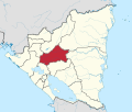
San Isidro (Spanish pronunciation: [san iˈsiðɾo]) is a municipality in the Matagalpa department of Nicaragua.
Climate
| Climate data for San Isidro, Nicaragua | |||||||||||||
|---|---|---|---|---|---|---|---|---|---|---|---|---|---|
| Month | Jan | Feb | Mar | Apr | May | Jun | Jul | Aug | Sep | Oct | Nov | Dec | Year |
| Mean daily maximum °C (°F) | 30.2 (86.4) |
31.1 (88.0) |
32.6 (90.7) |
33.5 (92.3) |
32.7 (90.9) |
30.8 (87.4) |
28.6 (83.5) |
31.3 (88.3) |
30.7 (87.3) |
30.1 (86.2) |
30.0 (86.0) |
30.0 (86.0) |
31.0 (87.8) |
| Daily mean °C (°F) | 24.6 (76.3) |
24.9 (76.8) |
28.1 (82.6) |
26.9 (80.4) |
26.9 (80.4) |
26.1 (79.0) |
26.0 (78.8) |
26.1 (79.0) |
25.4 (77.7) |
24.1 (75.4) |
24.7 (76.5) |
24.8 (76.6) |
25.7 (78.3) |
| Mean daily minimum °C (°F) | 19.1 (66.4) |
18.6 (65.5) |
19.5 (67.1) |
19.4 (66.9) |
21.2 (70.2) |
21.2 (70.2) |
20.8 (69.4) |
20.9 (69.6) |
20.3 (68.5) |
19.9 (67.8) |
19.5 (67.1) |
19.4 (66.9) |
20.0 (68.0) |
| Average precipitation mm (inches) | 2 (0.1) |
1 (0.0) |
5 (0.2) |
22 (0.9) |
125 (4.9) |
160 (6.3) |
71 (2.8) |
102 (4.0) |
176 (6.9) |
150 (5.9) |
42 (1.7) |
6 (0.2) |
863 (34.0) |
| Average precipitation days (≥ 1.0 mm) | 1 | 0 | 1 | 2 | 8 | 13 | 9 | 11 | 14 | 14 | 5 | 2 | 79 |
| Source: National Oceanic and Atmospheric Administration (temperatures 1961–1987, precipitation 1961–1990) | |||||||||||||
References
- "Google Maps".
- "Station Name: SAN ISIDRO DE BARBACOA" (TXT). National Oceanic and Atmospheric Administration. Retrieved 17 September 2024.
| Capital: Matagalpa | ||
| Municipalities |  | |
12°55′55″N 86°11′43″W / 12.93194°N 86.19528°W / 12.93194; -86.19528
This Nicaragua location article is a stub. You can help Misplaced Pages by expanding it. |