Human settlement in England
| Sandridge | |
|---|---|
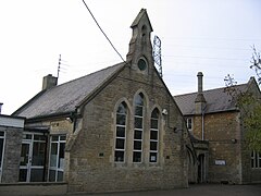
 Former Church of England School Former Church of England School | |
 | |
| OS grid reference | ST9364 |
| Civil parish | |
| Unitary authority | |
| Ceremonial county | |
| Region | |
| Country | England |
| Sovereign state | United Kingdom |
| Post town | Melksham |
| Postcode district | SN12 |
| Post town | Chippenham |
| Postcode district | SN15 |
| Dialling code | 01225 |
| Police | Wiltshire |
| Fire | Dorset and Wiltshire |
| Ambulance | South Western |
| UK Parliament | |
| 51°23′N 2°06′W / 51.38°N 02.10°W / 51.38; -02.10 | |
Sandridge is a dispersed rural community to the east of Melksham, Wiltshire, England. It is part of the civil parish of Melksham Without.
An Ordnance Survey map of 1961 names a settlement at Sandridge Hill, 2.5 miles (4.0 km) east of Melksham, and a hamlet of Sandridge, 0.25 miles (0.4 km) to the north; as of 2015 these names are no longer in gazetteers and Sandridge refers to a wider area along the A3102, with Sandridge Common identified on road signs near Melksham.
A National School was built in 1873 at Sandridge Common, on land given by Ralph Ludlow Lopes and educated children of all ages until 1953; around that time it became known as Forest and Sandridge Church of England Primary School. In 2015, to cater for the eastward expansion of Melksham, the school moved to a new building on the outskirts of the town.
Sandridge Park
Sandridge Park (not to be confused with Sandridge Park, Devon) is an ashlar-faced country house which stands in parkland north of the A3102, about 2 miles (3 km) east of Melksham. The two-storey house was built between 1856 and 1859 for Henry Lopes. After being used for a time as a hotel, it was sold in 2018 as an eight-bedroom house for £2.8m.
The former coach house and stables of the same date, now converted into a house, is Grade II listed. Further uphill on the other side of the road is Sandridge Tower, a former folly belonging to Sandridge Park, also now a house. Built in ashlar in the late 19th century, its four storeys are topped by a battlemented parapet.
References
- "Ordnance Survey 1:25,000 maps of Great Britain, sheet ST96". National Library of Scotland. 1961. Retrieved 30 December 2015.
- Yilmaz, Tanya (8 October 2015). "Nostalgic memories for past and present pupils as Forest and Sandridge celebrates 140 years". Wiltshire Times. Retrieved 14 February 2019.
- "Forest & Sandridge C. of E. Primary School". Wiltshire Community History. Wiltshire Council. Retrieved 30 December 2015.
- Yilmaz, Tanya (23 September 2015). "Top marks as new Melksham school opens its doors". Wiltshire Times. Retrieved 30 December 2015.
- Orbach, Julian; Pevsner, Nikolaus; Cherry, Bridget (2021). Wiltshire. The Buildings Of England. New Haven, US and London: Yale University Press. p. 470. ISBN 978-0-300-25120-3. OCLC 1201298091.
- "Sandridge Common, Melksham, Wiltshire, SN12 8 bed detached house". Knight Frank. OnTheMarket. Retrieved 14 February 2019.
- "Property details for Sandridgre Park House". Zoopla. Retrieved 14 February 2019.
- Historic England. "The Old Coach House (1194747)". National Heritage List for England. Retrieved 14 February 2019.
- Historic England. "Sandridge Tower (1021771)". National Heritage List for England. Retrieved 8 December 2022.
External links
- "Melksham Without". Wiltshire Community History. Wiltshire Council. Retrieved 30 December 2015.
- "Sandridge". Melksham Without Parish Council. Retrieved 8 December 2022.
![]() Media related to Sandridge, Wiltshire at Wikimedia Commons
Media related to Sandridge, Wiltshire at Wikimedia Commons