Human settlement in Scotland
| Sandwick | |
|---|---|
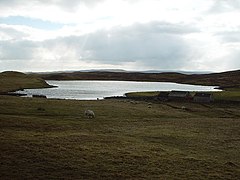
 Loch of Sandwick, Whalsay, Shetland Loch of Sandwick, Whalsay, Shetland | |
 | |
| OS grid reference | HU540618 |
| Civil parish | |
| Council area | |
| Lieutenancy area | |
| Country | Scotland |
| Sovereign state | United Kingdom |
| Post town | SHETLAND |
| Postcode district | ZE2 |
| Dialling code | 01806 |
| Police | Scotland |
| Fire | Scottish |
| Ambulance | Scottish |
| UK Parliament | |
| Scottish Parliament | |
| 60°20′13″N 1°01′16″W / 60.337°N 1.021°W / 60.337; -1.021 | |
Sandwick is a hamlet, often considered part of the main village of Symbister along with adjacent Harlsdale, in the parish of Nesting in southwestern Whalsay in the Shetland Islands of Scotland. It is located to the south of the main centre of Symbister; Clate lies just to the south. The Holm of Sandwick lies off the coast. The British military established a radar camp in the vicinity during wartime and tanks and sheds built by the military were still in use in 1986. A Catalina bomber crashed in the vicinity in the early part of World War II. The Loch of Sandwick lies to the west of the village. There are burnt mounds in the lake area and caves along the coast here.
References
- 544612 "Brough, HU 544 612 GB Grid". Ordnance Survey. Retrieved 1 February 2013.
{{cite web}}: Check|url=value (help) - ^ Cohen, Anthony Paul (1986). Symbolising Boundaries: Identity and Diversity in British Cultures. Manchester University Press. p. 15. ISBN 978-0-7190-2201-2. Retrieved 1 February 2013.
- Great Britain. Scottish Development Dept; Great Britain. Scottish Office (1983). List of ancient monuments in Scotland. HMSO, Scottish Development Dept. ISBN 9780114922894. Retrieved 5 February 2013.
External links
| Whalsay | ||
|---|---|---|
| Settlements | ||
| Geography |
| |
| Archaeological sites | ||
| Buildings | ||
This Shetland location article is a stub. You can help Misplaced Pages by expanding it. |