| Sanriku Fukkō National Park | |
|---|---|
| 三陸復興国立公園 | |
| IUCN category II (national park) | |
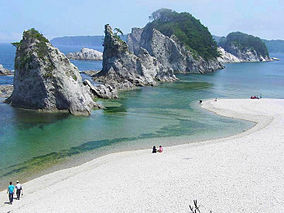
 Jōdogahama in 2007 (Place of Scenic Beauty) Jōdogahama in 2007 (Place of Scenic Beauty) | |
  | |
| Location | Tōhoku, Japan |
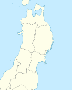
| Coordinates | 39°38′N 141°58′E / 39.633°N 141.967°E / 39.633; 141.967 |
| Area | 285.37 km (110.18 sq mi) |
| Established | 24 May 2013 |
| Governing body | Ministry of the Environment (Japan) |
Sanriku Fukkō National Park (三陸復興国立公園, Sanriku Fukkō Kokuritsu Kōen, lit. 'Sanriku Reconstruction National Park') is a national park extending along the Sanriku Coast of Japan from Hachinohe in Aomori Prefecture through Iwate Prefecture to Kesennuma in Miyagi Prefecture. The national park was created on 24 May 2013 and covers a land area of 28,537 hectares (110.18 sq mi).
History
On 2 May 1955 the Rikuchū Kaigan National Park (陸中海岸国立公園, Rikuchū Kaigan Kokuritsu Kōen) was created in the Tōhoku region of Honshū in northern Japan. The park extended for 180 kilometers from north to south along the coastline of the Pacific Ocean from northern Miyagi prefecture to northern Iwate prefecture. It had a land area of 121.98 square kilometers (47.10 sq mi). On 24 May 2013 the park was incorporated into Sanriku Fukkō National Park. This was in the aftermath of the 2011 Tōhoku earthquake and tsunami. It also includes the former Tanesashi Kaigan Hashikamidake Prefectural Natural Park. On 31 March 2015, the Ministry of the Environment extended the park to include the former Minami Sanriku Kinkasan Quasi-National Park. Subsequently, the park will be extended to include Kesennuma Prefectural Natural Park, Kenjōsan Mangokuura Prefectural Natural Park, and Matsushima Prefectural Natural Park.
Geography
The entire coastline is noted for examples of sea erosion, with numerous rock pillars and islands. The northern coast is an example of an uplifted coastline, and is an area which has been subject to several strong earthquakes and tsunami in recent history. The southern coast is an example of a ria coastline of submerged river valleys, with deep inlets and narrow peninsulas, forming many small bays and coves.
At the northern part of the national park there is an 8-kilometer-long (5.0 mi) and 200-meter-high (660 ft) set of cliffs called the Kita Yamazaki. The scenic coastal rock formations are nicknamed the "Alps of the Sea".
Related municipalities
Aomori: Hachinohe, Hashikami
Iwate: Fudai, Iwaizumi, Kamaishi, Kuji, Miyako, Noda, Ōfunato, Ōtsuchi, Rikuzentakata, Tanohata, Yamada
Miyagi: Ishinomaki, Kesennuma, Minamisanriku, Onagawa, Tome
Flora and Fauna
Flora includes groves of Japanese red pine, rhododendrons and Rosa rugosa. Fauna includes numerous bird species, including the black-tailed gull and shearwater. In terms of larger animals, there have also been sightings of the kamoshika.
Gallery
-
 Kabushima Black-tailed gull large breeding ground
-
 Kosode coast with a suspended cave
-
 Kurosaki / Anmoura Observatory
-
 Kitayamazaki
-
 Miracle ipponmatsu
-
 Goishi Coast
-
 Oogamahanzo
-
 Kinkasan island
See also
References
- 浄土ヶ浜 [Jōdogahama] (in Japanese). Agency for Cultural Affairs. Archived from the original on 8 December 2019. Retrieved 22 October 2013.
- ^ 基礎情報 [Basic Information] (in Japanese). Ministry of the Environment. Archived from the original on 23 October 2013. Retrieved 22 October 2013.
- 三陸復興国立公園の公園区域の変更(南三陸金華山国定公園区域の編入)について [About the Change in Area of Sanriku Fukkō National Park] (Transfer of the Area of Minami Sanriku Kinkasan Quasi-National Park)] (in Japanese). Ministry of the Environment. 27 March 2015. Retrieved 17 August 2019.
- "National park of restoration". The Japan Times. 28 May 2013. Retrieved 22 October 2013.
- Katsuragawa Hiroki. "Green reconstruction through the creating a new Sanriku Fukko (reconstruction) National Park" (PDF). IUCN. Archived from the original (PDF) on 23 October 2013. Retrieved 22 October 2013.
- "三陸北部森林管理署の見所" [Northern Sanriku Forest Management Station highlights]. Tōhoku Regional Forest Office (in Japanese). 2008. Retrieved 6 July 2020.
- 三陸復興国立公園 [Sanriku Fukkō National Park] (in Japanese). Ministry of the Environment. Retrieved 17 August 2019.
External links
- (in English) Sanriku Fukko National Park - National Parks of Japan
- (in Japanese) Sanriku Fukko National Park - National Parks of Japan
- Sanriku Fukko National Park Association
- IUCN Category II
- National parks of Japan
- Parks and gardens in Aomori Prefecture
- Parks and gardens in Iwate Prefecture
- Parks and gardens in Miyagi Prefecture
- Protected areas established in 2013
- Parks and gardens in Hachinohe
- Hashikami, Aomori
- Miyako, Iwate
- Ōfunato, Iwate
- Kuji, Iwate
- Rikuzentakata, Iwate
- Kamaishi, Iwate
- Ōtsuchi, Iwate
- Noda, Iwate
- Yamada, Iwate
- Iwaizumi, Iwate
- Fudai, Iwate
- Tanohata, Iwate
- Ishinomaki
- Kesennuma
- Tome, Miyagi
- Onagawa, Miyagi
- Minamisanriku, Miyagi
