| This article needs additional citations for verification. Please help improve this article by adding citations to reliable sources. Unsourced material may be challenged and removed. Find sources: "Santa Rosa historic landmarks" – news · newspapers · books · scholar · JSTOR (March 2021) (Learn how and when to remove this message) |
Santa Rosa, California's Cultural Heritage Board recommends sites for Designated Landmark status. The City Council makes the final decisions regarding designations.
Santa Rosa's designations are independent of state and federal designations; the Luther Burbank Home & Gardens however is also designated a California Historical Landmark and as a U.S. National Historic Landmark (and therefore is also listed on the National Register of Historic Places. The County of Sonoma's historic landmark designations intentionally exclude sites within the cities in the County.
Map all coordinates using OpenStreetMapDownload coordinates as:
List of Santa Rosa historic landmarks
| Landmark Number | Name | Location | Image | CHB Resolution No./ CHB Date |
CC Resolution No./ CC Date |
Notes | APNs |
|---|---|---|---|---|---|---|---|
| 1 | Miller Ranch (Stone Family Farm) | Occidental & Sanford Roads 38°25′31″N 122°49′31″W / 38.425217°N 122.825224°W / 38.425217; -122.825224 (Miller Ranch (Stone Family Farm)) |
 |
chb4/ 10/26/1988 |
130-250-14, 130-250-49, 130-250-50, 060-330-10 | ||
| 2 | De Turk Round Barn | 819 Donahue Street 38°26′27″N 122°43′31″W / 38.440815°N 122.725211°W / 38.440815; -122.725211 (De Turk Round Barn) |
 |
chb8/ 11/9/1988 |
Now in a city park available for rent for weddings and events. | 010-144-19 | |
| 3 | Carrillo Adobe | Montomery Drive38°26′55″N 122°41′01″W / 38.448548°N 122.683604°W / 38.448548; -122.683604 (Carrillo Adobe) |  |
chb11/ 11/29/1988 |
013-271-01, 013-274-02 | ||
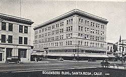
| 4 | Rosenberg Building | 306 Mendocino Avenue 38°26′27″N 122°42′51″W / 38.440837°N 122.714155°W / 38.440837; -122.714155 (Rosenberg Building) |

|
chb13/ 3/22/1989 |
009-011-02 | ||
| 5 | Bolton House | 966 Sonoma Avenue 38°26′24″N 122°42′11″W / 38.439968°N 122.702917°W / 38.439968; -122.702917 (Bolton House) |
 |
chb15/ 6/14/1989 |
009-211-81 | ||
| 6 | Tripp House | 1023 Fourth Street 38°26′39″N 122°42′24″W / 38.444032°N 122.706736°W / 38.444032; -122.706736 (Tripp House) |
 |
chb16/ 9/13/1989 |
009-102-34 | ||
| 7 | Luther Burbank Home & Gardens | Southeast corner of Santa Rosa and Sonoma Avenues 38°26′10″N 122°42′43″W / 38.436102°N 122.711809°W / 38.436102; -122.711809 (Luther Burbank Home & Gardens) |

|
chb29/ 1/23/1991 |
California Historical Landmark #234, and a U.S. National Historic Landmark | 009-265-15, 009-265-28 | |
| 8 | 312, 316 Chinn Street - Structures Adjacent to Tripp House | 1023 Fourth Street 38°26′39″N 122°42′24″W / 38.444032°N 122.706736°W / 38.444032; -122.706736 (312, 316 Chinn Street) |
  |
chb41/ 8/26/1992 |
cc21023/ 9/29/1992 |
009-102-20, 009-102-34 | |
| 9 | Coddingtown Revolving sign Tower | 101 Coddingtown Center 38°27′31″N 122°43′38″W / 38.458578°N 122.727114°W / 38.458578; -122.727114 (Coddingtown Revolving sign Tower) |
 |
chb44
/ |
cc21185/ 1/26/1993 |
||
| 10 | Rosenberg's Department Store | 700 Fourth Street 38°26′28″N 122°42′42″W / 38.441194°N 122.711698°W / 38.441194; -122.711698 (Rosenberg's Department Store) |

|
chb47/ 4/27/1994 |
cc21775/ 6/7/1994 |
Principal tenant in 2019 is Barnes & Noble | 009-014-12 |
| 11 | Santa Rosa Plaque | Hampton Woods property, at the confluence of Santa Rosa Creek and Brush Creek |  |
chb49/ 4/27/1994 |
|||
| 12 | Hoag House | 6102 Sonoma Highway |  |
chb61/ 8/23/1995 |
cc22426/ 10/3/1995 |
Dismantled and stored by City of Santa Rosa. Inadequate protection led to loss of entire fabric of remaining materials. | |
| 13 | unassigned | ||||||
| 14 | Sara Building (Sibbald-Donovan Manor) | 725 College Avenue 38°26′45″N 122°42′49″W / 38.445736°N 122.713746°W / 38.445736; -122.713746 (Sara Building (Sibbald-Donovan Manor)) |
 |
chb0062/ 1/24/1996 |
cc22610/ 3/5/1996 |
012-023-011 | |
| 15 | Flamingo Resort Sign Tower to include neon-outlined flamingo atop the sign tower | 2777 Fourth Street 38°27′03″N 122°41′19″W / 38.450862°N 122.688564°W / 38.450862; -122.688564 (Flamingo Resort Sign Tower) |
 |
chb65/ 10/23/1996 |
cc22990/ 1/14/1997 |
032-030-002 | |
| 16 | Santa Rosa Rural Cemetery | 1900 Franklin Avenue 38°27′20″N 122°42′15″W / 38.455624°N 122.704274°W / 38.455624; -122.704274 (Santa Rosa Rural Cemetery) |
 |
chb72/ 6/11/1997 |
cc23251/ 8/19/1997 |
015-281-002, 015-281-004, 015-281-006 | |
| 17 | Church of One Tree | 492 Sonoma Avenue 38°26′10″N 122°42′51″W / 38.436004°N 122.714060°W / 38.436004; -122.714060 (Church of One Tree) |

|
chb77/ 11/12/1997 |
cc23412/ 1/13/1998 |
Moved from Ross and B Streets by the City of Santa Rosa in 1957. Now in Juilliard Park on Sonoma Avenue and available to rent for events. | 010-208-022 |
| 18 | Rose Park House | 406 Chinn Street 38°26′41″N 122°42′25″W / 38.444756°N 122.707066°W / 38.444756; -122.707066 (Rose Park House) |
 |
chb79/ 1/14/1998 |
cc23476/ 3/24/1998 |
009-102-023 | |
| 19 | Fountaingrove Round Barn | 3535 Round Barn Boulevard 38°28′33″N 122°43′39″W / 38.475700°N 122.727450°W / 38.475700; -122.727450 (Fountaingrove Round Barn) |
 |
chb98/ 2/9/2000 |
cc24329/ 3/21/2000 |
burned completely in Tubbs Fire in 2017 | 173-020-004 |
| 20 | Alexander House | 412 Humboldt Street 38°26′32″N 122°42′47″W / 38.442188°N 122.713142°W / 38.442188; -122.713142 (Alexander House) |
 |
chb1148/ 3/26/2003 |
cc25668/ 6/10/2003 |
||
| 21 | Community Baptist Church | 1228 Grand Avenue 38°25′37″N 122°42′24″W / 38.426882°N 122.706669°W / 38.426882; -122.706669 (Community Baptist Church) |
 |
chb216/ 7/19/2006 |
cc3794/ 10/10/2006 |
File No. STU05-014 | |
| 22 | Dutton Avenue Queen Anne | 895 Dutton Avenue 38°25′38″N 122°43′31″W / 38.427237°N 122.725169°W / 38.427237; -122.725169 (Dutton Avenue Queen Anne) |
 |
chb244/ 3/5/2008 |
125-271-005 |
See also
- List of National Historic Landmarks in California
- California Historical Landmarks in Sonoma County, California
References
- "Historic Preservation". City of Santa Rosa. Retrieved 2021-01-27.
- CITY OF SANTA ROSA CULTURAL HERITAGE BOARD: DESIGNATED LANDMARKS (Report). City of Santa Rosa.