| This article needs additional citations for verification. Please help improve this article by adding citations to reliable sources. Unsourced material may be challenged and removed. Find sources: "Santander de Quilichao" – news · newspapers · books · scholar · JSTOR (January 2021) (Learn how and when to remove this message) |
| Santander de Quilichao | |
|---|---|
| City | |
 Saman tree Saman tree | |
 Flag Flag Seal Seal | |
| Nickname: City of the Samanes | |
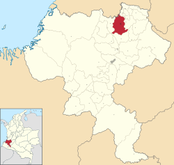
 Location of the city Santander de Quilichao. Location of the city Santander de Quilichao. | |
 | |
| Coordinates: 3°00′47″N 76°19′12″W / 3.01306°N 76.32000°W / 3.01306; -76.32000 | |
| Country | |
| Department | Cauca Department |
| Founded | July 16, 1543 |
| Government | |
| • Mayor | Luís Eduardo Grijalba |
| Area | |
| • City | 518.2 km (200.1 sq mi) |
| • Urban | 10.880 km (4.201 sq mi) |
| Elevation | 1,071 m (3,514 ft) |
| Population | |
| • City | 220,000 |
| • Density | 420/km (1,100/sq mi) |
| • Urban | 180,000 |
| • Urban density | 17,000/km (43,000/sq mi) |
| • Metro | 180,000 |
| Demonym | Quilichagüeño |
| Time zone | UTC-5 (Colombia Standard Time) |
| Area code | 57 + 2 |
| Climate | Af |
| Website | Official website (in Spanish) |
Santander de Quilichao is a city in the north of the Cauca Department, Colombia at 97 km to the north of Popayán and 45 km to the south of Cali.
Climate
| Climate data for Santander de Quilichao (Japio), elevation 1,015 m (3,330 ft), (1981–2010) | |||||||||||||
|---|---|---|---|---|---|---|---|---|---|---|---|---|---|
| Month | Jan | Feb | Mar | Apr | May | Jun | Jul | Aug | Sep | Oct | Nov | Dec | Year |
| Mean daily maximum °C (°F) | 29.0 (84.2) |
29.2 (84.6) |
29.3 (84.7) |
28.9 (84.0) |
28.6 (83.5) |
28.8 (83.8) |
29.4 (84.9) |
30.2 (86.4) |
29.5 (85.1) |
28.7 (83.7) |
28.2 (82.8) |
28.5 (83.3) |
29.0 (84.2) |
| Daily mean °C (°F) | 23.5 (74.3) |
23.7 (74.7) |
23.6 (74.5) |
23.5 (74.3) |
23.4 (74.1) |
23.5 (74.3) |
23.6 (74.5) |
24.1 (75.4) |
23.8 (74.8) |
23.3 (73.9) |
23.1 (73.6) |
23.4 (74.1) |
23.6 (74.5) |
| Mean daily minimum °C (°F) | 18.5 (65.3) |
18.5 (65.3) |
18.7 (65.7) |
18.8 (65.8) |
18.7 (65.7) |
18.3 (64.9) |
17.5 (63.5) |
17.5 (63.5) |
18.0 (64.4) |
18.4 (65.1) |
18.6 (65.5) |
18.7 (65.7) |
18.3 (64.9) |
| Average precipitation mm (inches) | 147.7 (5.81) |
141.2 (5.56) |
180.7 (7.11) |
224.4 (8.83) |
159.8 (6.29) |
93.3 (3.67) |
51.1 (2.01) |
67.4 (2.65) |
113.0 (4.45) |
212.0 (8.35) |
228.4 (8.99) |
167.1 (6.58) |
1,786.2 (70.32) |
| Average precipitation days | 12 | 11 | 14 | 16 | 13 | 10 | 7 | 6 | 11 | 16 | 16 | 13 | 145 |
| Average relative humidity (%) | 78 | 78 | 78 | 80 | 80 | 79 | 75 | 72 | 75 | 79 | 80 | 79 | 78 |
| Source: Instituto de Hidrologia Meteorologia y Estudios Ambientales | |||||||||||||
References
- Citypopulation.de Population of Santander de Quilichao municipality
- "Promedios Climatológicos 1981–2010" (in Spanish). Instituto de Hidrologia Meteorologia y Estudios Ambientales. Archived from the original on 15 August 2016. Retrieved 17 June 2024.
External links
- (in Spanish) Santander de Quilichao official website
3°01′N 76°29′W / 3.017°N 76.483°W / 3.017; -76.483
This Department of Cauca location article is a stub. You can help Misplaced Pages by expanding it. |