Census-designated place in Iowa, United States
| Sexton, Iowa | |
|---|---|
| Census-designated place | |
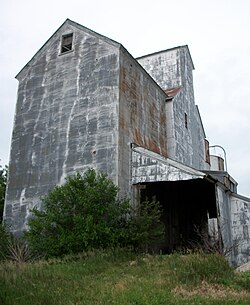
 Sexton elevator Sexton elevator | |
  | |
| Coordinates: 43°04′58″N 94°05′21″W / 43.08278°N 94.08917°W / 43.08278; -94.08917 | |
| Country | |
| State | |
| County | Kossuth |
| Townships | Irvington, Prairie |
| Post office opened | August 20, 1888 |
| Area | |
| • Total | 2.20 sq mi (5.70 km) |
| • Land | 2.20 sq mi (5.70 km) |
| • Water | 0.00 sq mi (0.00 km) |
| Elevation | 1,220 ft (370 m) |
| Population | |
| • Total | 46 |
| • Density | 20.89/sq mi (8.07/km) |
| Time zone | UTC-6 (Central (CST)) |
| • Summer (DST) | UTC-5 (CDT) |
| ZIP Code | 50483 |
| Area code | 515 |
| GNIS feature ID | 461516 |
| FIPS code | 19-71715 |
Sexton is an unincorporated community and census-designated place in Irvington Township, Kossuth County, Iowa, United States. It is located at the intersection of U.S. Route 18 and Kossuth CR P60. As of the 2020 census it had a population of 46.
History
Sexton was platted in 1889. Sexton's population was 42 in 1902.
The town contained a post office from August 1888 until May 1974.
A few houses, a Racer's Bar and Grill and the Sexton elevator remain.
Geography
Sexton is in southeastern Kossuth County, 8 miles (13 km) east of Algona, the county seat, and 5 miles (8 km) west of Wesley. According to the U.S. Census Bureau, the Sexton CDP has an area of 2.2 square miles (5.7 km), all land. The CDP is on the south side of U.S. Route 18.
Demographics
| Census | Pop. | Note | %± |
|---|---|---|---|
| 2010 | 37 | — | |
| 2020 | 46 | 24.3% | |
| U.S. Decennial Census | |||
2020 census
As of the census of 2020, there were 46 people, 19 households, and 12 families residing in the community. The population density was 20.9 inhabitants per square mile (8.1/km). There were 19 housing units at an average density of 8.6 per square mile (3.3/km). The racial makeup of the community was 91.3% White, 4.3% Black or African American, 0.0% Native American, 4.3% Asian, 0.0% Pacific Islander, 0.0% from other races and 0.0% from two or more races. Hispanic or Latino persons of any race comprised 0.0% of the population.
Of the 19 households, 26.3% of which had children under the age of 18 living with them, 63.2% were married couples living together, 5.3% were cohabitating couples, 0.0% had a female householder with no spouse or partner present and 31.6% had a male householder with no spouse or partner present. 36.8% of all households were non-families. 31.6% of all households were made up of individuals, 26.3% had someone living alone who was 65 years old or older.
The median age in the community was 28.5 years. 21.7% of the residents were under the age of 20; 13.0% were between the ages of 20 and 24; 30.4% were from 25 and 44; 17.4% were from 45 and 64; and 17.4% were 65 years of age or older. The gender makeup of the community was 50.0% male and 50.0% female.
References
- "2020 U.S. Gazetteer Files". United States Census Bureau. Retrieved March 16, 2022.
- "Feature Detail Report for: Sexton." USGS. URL Retrieved June 26, 2010.
- Reed, Benjamin F. (1913). History of Kossuth County, Iowa, Volume 1. S. J. Clarke Publishing Company. p. 589.
- Cram's Modern Atlas: The New Unrivaled New Census Edition. J. R. Gray & Company. 1902. pp. 203–207.
- "Feature Detail Report for: Sexton Post Office (historical)." USGS. URL Retrieved June 26, 2010.
- "Geographic Identifiers: 2010 Demographic Profile Data (G001): Sexton CDP, Iowa". American Factfinder. U.S. Census Bureau. Retrieved February 28, 2019.
- "Census of Population and Housing". Census.gov. Retrieved June 4, 2016.
- "2020 Census". United States Census Bureau.
| Municipalities and communities of Kossuth County, Iowa, United States | ||
|---|---|---|
| County seat: Algona | ||
| Cities | ||
| Townships | ||
| CDPs | ||
| Unincorporated communities | ||
| Ghost town | ||
| Footnotes | ‡This populated place also has portions in an adjacent county or counties | |
