| Statistics | |
|---|---|
| Capital: | Ban Mouang Cha |
| Area: | 7,105 km |
| Inhabitants: | 70,600 (2004 est) |
| Pop. density: | 10 inhabitants/km |
| ISO 3166-2: | LA-XN |
| Geocode: | 1800 |
| Map | |

| |
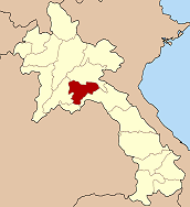
Xaisomboun (also Saysomboun, Lao: ໄຊສົມບູນ) was a special zone (khetphiset) of Laos, located in the north of the country, near the capital Vientiane. The special zone was created 1994 by the military, with area split off from the provinces Vientiane and Xiangkhoang, in order to control and suppress the postwar Hmong resistance. It was officially dissolved on January 13, 2006, although the term continues to be used.
Geography
The special zone of Xaisomboun is in a mountainous region south of the Plain of Jars. It contains the tallest mountain in Laos, Phou Bia, and the protected area Phou Khao Khouay.
Military control
The area of the special zone of Xaisomboun was once controlled by the Hmong "Secret Army" and included the military bases Long Tieng and Sam Thong; today it is controlled by the Lao People's Army (LPA), which have put pressure on Hmong insurgents. Into 2016, the Laotian government continued to deny access to officials from the European Union and the United Nations, despite reports of killings by the military, including killings using chemical weapons.
In 2021, the Unrepresented Nations and Peoples Organization (UNPO) condemned the treatment and military violence against the ChoaFa people living in the special zone of Xaisomboun, as well as "intimidation, harassment and persecution of human rights defenders, journalists, and members of minority communities through arbitrary arrests and enforced disappearances".
Administrative divisions
The province was originally made up of the following districts:
- Hom (18-03)
- Longsane (18-04)
- Phun (18-05)
- Thathom (18-02)
- Anouvong (18-01)
History
- 23 September 2004 – The districts Hom and Longsane were merged. The new district, still named Hom, was reassigned to Vientiane Province.
- 27 June 2005 – The districts Phun and Xaisomboun were merged, with the new district still named Xaisomboun.
- 13 January 2006 – Xaisomboun District was reassigned to Vientiane Province, while Thathome District went to Xiangkhoang Province. Therefore, the special area of Xaisomboun was dissolved.
See also
References
- Das, Dilip K. (2006). World Police Encyclopedia: L-Z, index. Taylor & Francis US. p. 478. ISBN 978-0-415-94252-2.
- ^ Stuart-Fox, Martin; Creak, Simon; Rathie, Martin (2023-02-06). Historical Dictionary of Laos. Rowman & Littlefield. p. 549. ISBN 978-1-5381-2028-6.
- Stuart-Fox, Martin (August 2003). "The Hmong Problem in Laos". The Irrawaddy. Retrieved 30 January 2024.
- KYUCHYUK, Ilhan. "Parliamentary question | VP/HR - The Hmong people in the jungle of the Lao People's Democratic Republic | E-009383/2016 | European Parliament". www.europarl.europa.eu. Retrieved 2024-01-31.
- "UNPO: Hmong". unpo.org. Retrieved 2024-01-31.
18°49′01″N 103°05′10″E / 18.81694°N 103.08611°E / 18.81694; 103.08611
Category: