 | |
| National monument of Ireland | |
|---|---|
| Official name | St Mullin's |
| Reference no. | 3 |
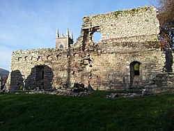
The monastic site in St Mullin's, County Carlow, Ireland, is an early medieval ecclesiastical site.
History
St Mullin's is located on the banks of the River Barrow, at the point where its tributary, the River Aughavaud meets it. The monastic site was found by Saint Moling at some point in the 7th century. It was renowned as a place of pilgrimage potentially since the pre-Christian period, when people may have traveled to the site to celebrate Lughnasadh. St Mullin's is traditionally associated with the Book of Mulling. In the early ninth century the monastery was plundered by vikings. In 1158, St Mullin's was granted to Ferns Abbey, part of the Augustinian order. In 1880, the ruins of the monastic site entered state care.
Buildings
A disused Anglican church is the northernmost building on the grounds, and was built in 1811.
References
Notes
- "National Monuments of County Carlow in State Care" (PDF). heritageireland.ie. National Monument Service. p. 2. Retrieved 12 July 2020.
- ^ Manning 1999a, p. 2.
- ^ The Library of Trinity College Dublin 2016.
- Manning 1999b, p. 132.
Sources
- Manning, Conleth (1999a). "Heritage Guide No. 5: St Mullin's: An early ecclesiastical site and medieval Settlement in County Carlow". Archaeology Ireland. ISSN 0790-892X.
- Manning, Conleth (1999b). "An Early Catholic Church at St. Mullin's, Co. Carlow". The Journal of the Royal Society of Antiquaries of Ireland. 129: 132–135. ISSN 0035-9106.
- The Library of Trinity College Dublin (2016-03-16). "St Mullin's". Trinity College Dublin. Retrieved 2022-07-12.
Further reading
- Ffrench, J. F. M. (December 1892). "St. Mullins, Co. Carlow". The Journal of the Royal Society of Antiquaries of Ireland. 2 (4): 377–388. ISSN 0035-9106.
52°29′19″N 6°55′39″W / 52.4887°N 6.9276°W / 52.4887; -6.9276
Categories: