| This article needs additional citations for verification. Please help improve this article by adding citations to reliable sources. Unsourced material may be challenged and removed. Find sources: "State Highway 48" New Zealand – news · newspapers · books · scholar · JSTOR (May 2016) (Learn how and when to remove this message) |
 State Highway 48
 | ||||
|---|---|---|---|---|
| Route information | ||||
| Maintained by NZ Transport Agency | ||||
| Length | 6.3 km (3.9 mi) | |||
| Major junctions | ||||
| Northwest end | ||||
| Southeast end | Whakapapa Village | |||
| Location | ||||
| Country | New Zealand | |||
| Highway system | ||||
| ||||

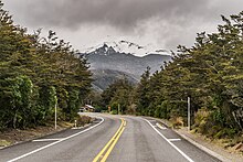
State Highway 48 (SH 48), also known as Bruce Road, is one of New Zealand's shortest state highways. It provides access to Whakapapa Skifield on the slopes of Mount Ruapehu. It is roughly 7 kilometres (4.3 mi) long and, with the exception of the junction with SH 47, it lies entirely within Tongariro National Park. SH 48 includes the highest point of the state highway network, 1,153 metres (3,783 ft) above sea level.
Route
The highway commences at a junction with SH 47, 9 kilometres (5.6 mi) east of National Park. It climbs rapidly, following the route of the young Whakapapa River, a tributary of the Whanganui. The highway terminates in Whakapapa Village at the visitors centre near the intersection of Rehua Place, from where an unclassified road winds the further 6 kilometres up the slopes to the skifield.
See also
References
- "State highway frequently asked questions, Useful facts and figures". NZ Transport Agency. Retrieved 19 May 2016.
- State Highway 48 on Google Maps
External links
| New Zealand state highways | ||
|---|---|---|
| National | ||
| North Island |
| |
| South Island | ||
| Former state highways | ||
| Touring routes | ||
39°11′00″S 175°31′38″E / 39.1833°S 175.5272°E / -39.1833; 175.5272
This New Zealand road or road transport-related article is a stub. You can help Misplaced Pages by expanding it. |