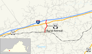
 State Route 90 State Route 90 | ||||
|---|---|---|---|---|
| Main Street | ||||
 | ||||
| Route information | ||||
| Maintained by VDOT | ||||
| Length | 1.73 mi (2.78 km) | |||
| Existed | 1933–present | |||
| Tourist routes | ||||
| Major junctions | ||||
| West end | ||||
| Major intersections | ||||
| East end | ||||
| Location | ||||
| Country | United States | |||
| State | Virginia | |||
| Counties | Wythe | |||
| Highway system | ||||
| ||||
State Route 90 (SR 90) is a primary state highway in the U.S. state of Virginia. Known as Main Street, the state highway runs 1.73 miles (2.78 km) from SR 616 and SR 749 north to Interstate 81 (I-81) within Rural Retreat in western Wythe County. SR 90 connects Rural Retreat with I-81 and U.S. Route 11 (US 11).
Route description

SR 90's southern terminus is at the center of the town of Rural Retreat at the intersection of Main Street and Baumgardner Avenue. Main Street continues south as SR 749 and Baumgardner Avenue is SR 616 in both directions. The state highway heads north and has a grade crossing of Norfolk Southern Railway's Pulaski District. SR 90 leaves the town limits and intersects US 11 (Lee Highway) at Staley Crossroads. The state highway continues to its northern terminus at the southbound ramps of its diamond interchange with I-81. The roadway continues north as SR 680 (Blacklick Road).
History
From about 1946 to 1952, this route ran from U.S. Route 21 in Speedwell, down what is now SR 749 into Rural Retreat, then down what is now SR 680, Blacklick Road, to U.S. Route 52 in Favonia, although the portion in between what is now U.S. 11 and I-81 was not part of the road until 1980. This routing also briefly took the road through Smyth County, and may explain why it is still signed as an east-west route even though it currently runs fully north-south.
Major intersections
The entire route is in Wythe County.
| Location | mi | km | Destinations | Notes | |
|---|---|---|---|---|---|
| | 0.00 | 0.00 | Exit 60 (I-81); western terminus | ||
| Rural Retreat | 0.47 | 0.76 | |||
| 1.73 | 2.78 | Eastern terminus | |||
| 1.000 mi = 1.609 km; 1.000 km = 0.621 mi | |||||
References
- ^ "2010 Traffic Data". Virginia Department of Transportation. 2010. Retrieved 2011-10-19.
- Wythe County (PDF)
- "Virginia State Route 90" (Map). Google Maps. Retrieved 2011-10-19.