You can help expand this article with text translated from the corresponding article in German. (January 2025) Click for important translation instructions.
|
| This article needs additional citations for verification. Please help improve this article by adding citations to reliable sources. Unsourced material may be challenged and removed. Find sources: "Garichtisee" – news · newspapers · books · scholar · JSTOR (January 2025) (Learn how and when to remove this message) |
| Garichtisee | |
|---|---|
 | |
   | |
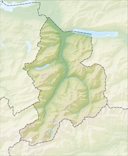
| Location | Canton of Glarus |
| Coordinates | 46°57′21″N 9°06′00″E / 46.95583°N 9.10000°E / 46.95583; 9.10000 |
| Type | reservoir |
| Catchment area | 7.8 km (3.0 sq mi) |
| Basin countries | Switzerland |
| Surface area | 16 ha (40 acres) |
| Surface elevation | 1,648 m (5,407 ft) |
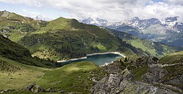
Garichtisee, also known as Mettmensee, is a reservoir on Mettmenalp above Schwanden in the Canton of Glarus, Switzerland. The lake's surface area is 16 ha (40 acres).
It is located at an elevation of 1,622 metres, within the Freiberg Kärpf, the oldest wildlife sanctuary in Europe.
See also
References
- Oehmigen, Karin. "Garichtig schön!". Schweizer LandLiebe (in German). Retrieved 1 January 2024.
External links
This Canton of Glarus location article is a stub. You can help Misplaced Pages by expanding it. |