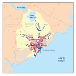
 Map of the Charleston Harbor watershed showing Stono River Map of the Charleston Harbor watershed showing Stono River | |
 | |
| Location | |
|---|---|
| Country | United States |
| State | South Carolina |
| Physical characteristics | |
| Source | |
| • coordinates | 32°42′36″N 80°11′24″W / 32.7099007°N 80.1900971°W / 32.7099007; -80.1900971 |
| Mouth | |
| • location | Atlantic Ocean |
| • coordinates | 32°38′13″N 80°00′54″W / 32.6368472°N 80.0150926°W / 32.6368472; -80.0150926 |
The Stono River or Creek is a tidal channel in southeast South Carolina, located southwest of Charleston. The channel runs southwest to northeast between the mainland and Wadmalaw Island and Johns Island, from north Edisto River between Johns (West) and James (East) Islands. The Intracoastal Waterway runs through southwest–northeast section of the channel.
In 1725, Columbian mammoth teeth were excavated from the vicinity by African slaves, with the slaves correctly noting the resemblance to teeth of African elephants from their homeland.
The Stono River is noted for the Stono Rebellion which started on September 9, 1739. Started by slaves from West Africa, likely from the Kingdom of Kongo, it became the largest slave uprising in the British mainland colonies prior to the American Revolution.
On June 20, 1779, it was also the site of the Battle of Stono Ferry during the American Revolution.
On January 30, 1863, as part of the American Civil War, a Confederate force captured the Union steamer USS Isaac Smith in which 8 men died and a further 17 were wounded in crossfire.
Bridges
See also
References
- Columbia University Press. "Stono River". Retrieved 2 November 2006.
- U.S. Geological Survey Geographic Names Information System: Stono River
- Elliott, Christian (22 February 2023). "The First Fossil Finders in North America Were Enslaved and Indigenous People". Smithsonian Magazine. Retrieved 2024-10-24.
This article related to a river in South Carolina is a stub. You can help Misplaced Pages by expanding it. |