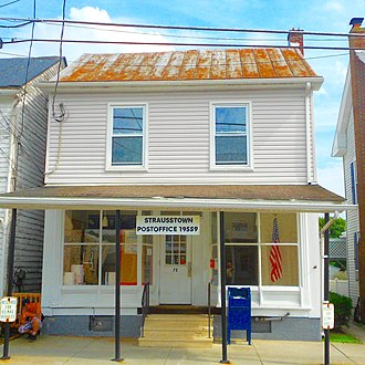
Unincorporated community & CDP in Pennsylvania, United States
| Strausstown, Pennsylvania | |
|---|---|
| Unincorporated community & CDP | |
 Zion Blue Mountain Church in Strausstown Zion Blue Mountain Church in Strausstown | |
 Location of Strausstown in Berks County, Pennsylvania Location of Strausstown in Berks County, Pennsylvania | |
  | |
| Coordinates: 40°29′31″N 76°11′03″W / 40.49194°N 76.18417°W / 40.49194; -76.18417 | |
| Country | United States |
| State | Pennsylvania |
| County | Berks |
| Township | Upper Tulpehocken |
| Area | |
| • Total | 0.17 sq mi (0.43 km) |
| • Land | 0.16 sq mi (0.42 km) |
| • Water | 0.00 sq mi (0.00 km) |
| Elevation | 574 ft (175 m) |
| Population | |
| • Total | 342 |
| • Estimate | 345 |
| • Density | 2,103.66/sq mi (814.20/km) |
| Time zone | UTC-5 (EST) |
| • Summer (DST) | UTC-4 (EDT) |
| ZIP Code | 19559 |
| Area code(s) | 610 and 484 |
| FIPS code | 42-74744 |
Strausstown is a census-designated place and former borough located in Upper Tulpehocken Township in Berks County, Pennsylvania. The population was 342 at the 2010 census.
Geography and history
Strausstown is located at 40°29′31″N 76°11′3″W / 40.49194°N 76.18417°W / 40.49194; -76.18417 (40.492053, -76.184102). According to the U.S. Census Bureau, the village has a total area of 0.2 square mile (0.5 km), all land.
Strausstown was founded in 1840 by John Strauss. It is located at the source of several tributaries to Northkill Creek.
In 2016, the borough of Strausstown voted to merge with surrounding Upper Tulpehocken Township.
Demographics
| Census | Pop. | Note | %± |
|---|---|---|---|
| 1880 | 310 | — | |
| 1930 | 326 | — | |
| 1940 | 339 | 4.0% | |
| 1950 | 368 | 8.6% | |
| 1960 | 380 | 3.3% | |
| 1970 | 401 | 5.5% | |
| 1980 | 377 | −6.0% | |
| 1990 | 353 | −6.4% | |
| 2000 | 339 | −4.0% | |
| 2010 | 342 | 0.9% | |
| 2016 (est.) | 345 | 0.9% | |
| Sources: | |||
As of the census of 2000, there were 339 people, 139 households, and 89 families residing in the borough. The population density was 1,919.6 inhabitants per square mile (741.2/km). There were 146 housing units at an average density of 826.7 per square mile (319.2/km). The racial makeup of the borough was 98.23% White, 1.47% Asian, and 0.29% from two or more races. Hispanic or Latino of any race were 0.59% of the population.
There were 139 households, out of which 28.8% had children under the age of 18 living with them, 52.5% were married couples living together, 5.8% had a female householder with no husband present, and 35.3% were non-families. 30.9% of all households were made up of individuals, and 14.4% had someone living alone who was 65 years of age or older. The average household size was 2.44 and the average family size was 3.08.
In the borough, the population was spread out, with 23.3% under the age of 18, 8.0% from 18 to 24, 28.3% from 25 to 44, 20.6% from 45 to 64, and 19.8% who were 65 years of age or older. The median age was 37 years. For every 100 females, there were 103.0 males. For every 100 females age 18 and over, there were 88.4 males.
The median income for a household in the borough was $38,125, and the median income for a family was $48,594. Males had a median income of $30,536 versus $21,250 for females. The per capita income for the borough was $19,733. About 3.5% of families and 5.0% of the population were below the poverty line, including 9.1% of those under age 18 and 6.0% of those age 65 or over.
Local events
The area's Strausstown Rod and Gun Club periodically hosts some of the state's best trap shooting events.
The Antique Auto Show & Flea Market is held annually at the Strausstown Lions Club Park.
References
- "2016 U.S. Gazetteer Files". United States Census Bureau. Retrieved July 4, 2017.
- ^ "Population and Housing Unit Estimates". Retrieved June 9, 2017.
- "US Gazetteer files: 2010, 2000, and 1990". United States Census Bureau. February 12, 2011. Retrieved April 23, 2011.
- Boor, Alison D. (Berger), Strausstown Roots, Our Family’s 20th Century History in Biographies, retrieved November 28, 2008
- Anthony Orozco. "Longtime residents of Strausstown fondly recall borough of yesteryear". Reading Eagle. Retrieved May 9, 2016.
- "Census of Population and Housing". U.S. Census Bureau. Retrieved December 11, 2013.
- ^ "U.S. Census website". United States Census Bureau. Retrieved January 31, 2008.
- "Incorporated Places and Minor Civil Divisions Datasets: Subcounty Resident Population Estimates: April 1, 2010 to July 1, 2012". Population Estimates. U.S. Census Bureau. Archived from the original on June 11, 2013. Retrieved December 11, 2013.


