| This article needs additional citations for verification. Please help improve this article by adding citations to reliable sources. Unsourced material may be challenged and removed. Find sources: "Celebes Sea" – news · newspapers · books · scholar · JSTOR (January 2023) (Learn how and when to remove this message) |
| Celebes Sea | |
|---|---|
| Sulawesi Sea | |
 | |
 | |
| Location | Southeast Asia |
| Coordinates | 3°N 122°E / 3°N 122°E / 3; 122 |
| Part of | Pacific Ocean |
| Basin countries | Indonesia, Malaysia, and Philippines |
| Max. length | 420 mi (680 km) |
| Max. width | 520 mi (840 km) |
| Surface area | 280,000 km (110,000 sq mi) |
| Max. depth | 20,300 ft (6,200 m) |
| Islands | |
| Settlements | |
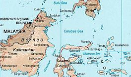
The Celebes Sea (/ˈsɛlɪbiːz, səˈliːbiz/ SEL-ib-eez, sə-LEE-beez; Filipino: Dagat Selebes) or Sulawesi Sea (Malay: Laut Sulawesi; Indonesian: Laut Sulawesi) of the western Pacific Ocean is bordered on the north by the Sulu Archipelago and Sulu Sea and Mindanao Island of the Philippines, on the east by the Sangihe Islands chain, on the south by Sulawesi's Minahasa Peninsula, and the west by northern Kalimantan in Indonesia. It extends 420 miles (675 km) north-south by 520 mi (840 km) east-west and has a total surface area of 110,000 square miles (280,000 km), to a maximum depth of 20,300 feet (6,200 m). South of the Cape Mangkalihat, the sea opens southwest through the Makassar Strait into the Java Sea.
The Celebes Sea is a piece of an ancient ocean basin that formed 42 million years ago in a locale removed from any landmass. By 20 million years ago, the earth's crust movement had moved the basin close enough to the Indonesian and Philippine volcanoes to receive emitted debris. By 10 million years ago the Celebes Sea was inundated with continental debris, including coal, which was shed from a growing young mountain on Borneo and the basin had docked against Eurasia.
The border between the Celebes and the Sulu Sea is at the Sibutu-Basilan Ridge. Strong ocean currents, deep sea trenches, and seamounts, combined with active volcanic islands, result in complex oceanographic features.
Delimitation of the Exclusive Economic Zone boundary
On 23 May 2013, the Government of the Republic of the Philippines and the Government of the Republic of Indonesia signed an agreement to establish the boundary line that delimits the overlapping Exclusive Economic Zone (EEZ) between the two countries. It has been agreed that north of the boundary line will be under the jurisdiction of the Philippines (named Mindanao Sea) and Indonesia be south of the boundary line (named Celebes Sea).
| Point | Latitude | Longitude |
|---|---|---|
| 1 | 3° 06’ 41 N | 119° 55’ 34 E |
| 2 | 3° 26’ 36 N | 121° 21′ 31 E |
| 3 | 3° 48′ 58 N | 122° 56′ 03 E |
| 4 | 4° 57′ 42 N | 124° 51′ 17 E |
| 5 | 5° 02′ 48 N | 125° 28’ 20 E |
| 6 | 6° 25′ 21 N | 127° 11′ 42 E |
| 7 | 6° 24′ 25 N | 128° 39′ 02″ E |
| 8 | 6° 24′ 20 N | 129° 31’ 31 E |
Extent
The International Hydrographic Organization (IHO) defines the Celebes Sea as being one of the waters of the East Indian Archipelago. The IHO defines its limits as follows:
On the North. The Southern limit of Sulu Sea and the Southwest coast of Mindanao.
On the East. A line from Tinaca Point, the Southern point of Mindanao, to the North point of Pulau Sangihe Besar (3°45′N 125°26′E / 3.750°N 125.433°E / 3.750; 125.433) thence through the pulau-pulau Sangihe to Tanjung Puisan, the Northeast extreme of Celebes .
On the South. The North coast of Celebes between tanjung Puisan and tanjung Binar (Cape Rivers) (1°20′N 120°52′E / 1.333°N 120.867°E / 1.333; 120.867) and thence a line to Tanjung Mangkalihat in Borneo, the Northern limit of Makassar Strait .
On the West. The East coast of Borneo is between Tanjung Mangkalihat and Tanjong Labian, the Southern limit of the Sulu Sea.
Marine life

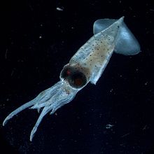
The Celebes Sea is home to a wide variety of fish and aquatic creatures. The tropical setting and warm clear waters permit it to harbor about 580 of the world's 793 species of reef-building corals, which grow as some of the most bio-diverse coral reefs in the world, and an impressive array of marine life, including whales and dolphins, sea turtles, manta rays, eagle rays, barracuda, marlin and other reef and pelagic species. Tuna and yellowfin tuna are also abundant. In addition to the high abundance of fish caught in the Celebes Sea, this sea also yields other aquatic products like sea tang.


Commercial significance
The Celebes Sea is an important sea route for regional trade. The sea is also popular for scuba diving and luxury ocean cruising.
Geology
The Celebes Sea is underlain by an oceanic plate with a mid-oceanic spreading in the center part. This plate is subducted to the south and north. Several seismic surveys and research drillings were done in this area to gather geological information.
See also
- Bunaken
- Davao Gulf
- Maitum, Sarangani
- Minahassa Peninsula
- Moro Gulf
- Sangir Islands
- Sarangani Bay
- Talaud Islands
References
- "Celebes". Dictionary.com Unabridged (Online). n.d.
- "Celebes Sea | sea, Pacific Ocean | Britannica". www.britannica.com. Retrieved 4 October 2022.
- C.Michael Hogan. 2011. Celebes Sea. Encyclopedia of Earth. Eds. P.Saundry & C.J.Cleveland. National Council for Science and the Environment. Washington DC
- "Agreement between the Government of the Republic of the Philippines and the Government of the Republic Indonesia concerning the delimitation of the Exclusive Economic Zone boundary". Official Gazette. Republic of the Philippines. 23 May 2014. Archived from the original on 13 June 2017. Retrieved 17 June 2014.
- Department of Foreign Affairs (23 May 2014). "Q&A on the Philippine and Indonesian agreement on the Exclusive Economic Zone Boundary". Republic of the Philippines. Archived from the original on 3 July 2014. Retrieved 17 June 2014.
- "Philippines-Indonesia Exclusive Economic Zone Boundary". Official Gazette. Republic of the Philippines. Archived from the original (png) on 26 March 2023. Retrieved 17 June 2014.
- "Limits of Oceans and Seas, 3rd edition" (PDF). International Hydrographic Organization. 1953. Retrieved 29 December 2020.
External links
- Ocean Explorer (www.oceanexplorer.noaa.gov) - Public outreach site for explorations sponsored by the Office of Ocean Exploration.
- Exploring the Inner Space of the Celebes Sea 2007 - A rich collection of images, video and audio podcast.
- NOAA, Ocean Explorer YouTube Channel
- Jose A. Ingles; Romeo B. Trono (2004). "Ecosystem Fisheries Management: A New Approach to Address Biodiversity Loss Caused by Fisheries in the Sulu-Sulawesi Seas". In Turbulent Seas: The Status of Philippine Marine Fisheries (PDF). Bureau of Fisheries and Aquatic Resources. pp. 336–341. ISBN 971-92753-4-0.
3°N 122°E / 3°N 122°E / 3; 122
Categories: