Unincorporated community in Arkansas, United States
| Sulphur Springs, Arkansas | |
|---|---|
| Unincorporated community | |
  | |
| Coordinates: 35°11′33″N 93°19′34″W / 35.19250°N 93.32611°W / 35.19250; -93.32611 | |
| Country | United States |
| State | Arkansas |
| County | Yell |
| Elevation | 456 ft (139 m) |
| Time zone | UTC-6 (Central (CST)) |
| • Summer (DST) | UTC-5 (CDT) |
| Area code | 479 |
| GNIS feature ID | 73777 |
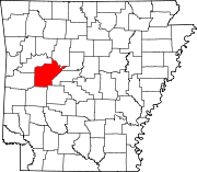
Sulphur Springs is an unincorporated community in northern Yell County, Arkansas, United States. The community is located approximately 10 miles (16 km) west-southwest of Dardanelle. The peak of Spring Mountain in southeast Logan County is about 1.5 miles to the north.
The Sulphur Springs Cemetery is listed on the National Register of Historic Places.
References
- ^ U.S. Geological Survey Geographic Names Information System: Sulphur Springs, Yell County, Arkansas
- Arkansas Atlas & Gazetteer, DeLorme, 2nd ed., 2004, p. 40 ISBN 0899333451
| Municipalities and communities of Yell County, Arkansas, United States | ||
|---|---|---|
| County seats: Danville and Dardanelle | ||
| Cities |  | |
| Town | ||
| CDPs | ||
| Other unincorporated communities | ||
| Footnotes | ‡This populated place also has portions in an adjacent county or counties | |
This article about a location in Yell County, Arkansas is a stub. You can help Misplaced Pages by expanding it. |