Human settlement in England
| Swallownest | |
|---|---|
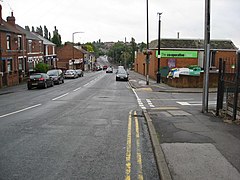
 High Street High Street | |
 | |
| Population | 15,022 |
| OS grid reference | SK449852 |
| Civil parish | |
| Metropolitan borough | |
| Metropolitan county | |
| Region | |
| Country | England |
| Sovereign state | United Kingdom |
| Post town | SHEFFIELD |
| Postcode district | S26 |
| Dialling code | 0114 |
| Police | South Yorkshire |
| Fire | South Yorkshire |
| Ambulance | Yorkshire |
| UK Parliament | |
| 53°21′44″N 1°19′30″W / 53.3623°N 1.3251°W / 53.3623; -1.3251 | |
Swallownest is a village in the civil parish of Aston cum Aughton and the Metropolitan Borough of Rotherham, South Yorkshire, England. The village is 4 miles (6.4 km) south of Rotherham and 7 miles (11 km) from Sheffield.
Swallownest borders the Sheffield suburb of Woodhouse to the west, Beighton to the southwest, the small village of Aston to the east, and Aughton to the north. The village is also served by Woodhouse railway station.
According to White's directory of 1833, Swallow Nest was the name of the Toll bar and public house, the home of J. Ward, a victualler and H. Ward, a wheelwright.
See also
References
- "Yorkshire and the Humber (United Kingdom): Counties and Unitary Districts & Settlements - Population Statistics, Charts and Map".
- White, William, ed. (1833). History, and General Directory, of the Borough of Sheffield, with Rotherham…. Sheffield. p. 372. Retrieved 5 February 2018 – via University of Leicester: Special Collections Online.
This South Yorkshire location article is a stub. You can help Misplaced Pages by expanding it. |