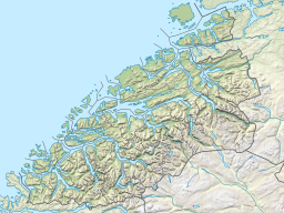
| Talgsjøen | |
|---|---|
 Talgsjøen seen from Kvernberg in Kristiansund Talgsjøen seen from Kvernberg in Kristiansund | |
  | |
| Location | Møre og Romsdal county, Norway |
| Coordinates | 63°8′42″N 7°52′19″E / 63.14500°N 7.87194°E / 63.14500; 7.87194 |
| Basin countries | Norway |
| Max. length | 10.0 kilometres (6.2 mi) |
| Max. width | 3.0 kilometres (1.9 mi) |
| Max. depth | 341 metres (1,119 ft) |
| Surface elevation | 0 m (0 ft) |
Talgsjøen is a small channel or fjord beyond Halsa Fjord between the municipalities of Kristiansund and Aure in Møre og Romsdal county, Norway.
The ferry connection from Seivika on the island of Nordlandet in Kristiansund and Tømmervåg on the island of Tustna in Aure crosses Talgsjøen.
References
- "Talgsjøen, Kristiansund (Møre og Romsdal)" (in Norwegian). yr.no. Retrieved March 15, 2017.
- Store norske leksikon: Kristiansund.
- Tåke stoppet ferga og fly. 2014. Tidens Krav (April 25).