| Taliwin Mountain | |
|---|---|
 Taliwin Mountain Taliwin Mountain | |
| Highest point | |
| Elevation | 1,698 m (5,571 ft) |
| Listing | Babor Mountains - Tell Atlas |
| Coordinates | 36°30′41″N 5°03′34″E / 36.5114557°N 5.0594186°E / 36.5114557; 5.0594186 |
| Geography | |
| Kendira - Barbacha District - Béjaïa Province | |
| Parent range | Babor Mountains - Tell Atlas |
| Geology | |
| Rock age | Quaternary |
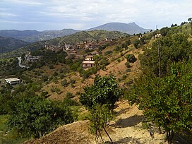
Taliwin Mountain is a mountain peak in the Babor mountain range within the Atlas Hill in Algeria, located in the municipality of Kendira in the Barbacha district in Béjaïa Province.
Description
Taliwin Mountain is the fourth highest mountain peak in Béjaïa, with an elevation of 1,698 m (5,571 ft), right after Babor Mountain (2,004 m (6,575 ft)) thenTakintosht (1,874 m (6,148 ft)), followed by Isak Mountain (1,742 m (5,715 ft)), and it overlooks the eastern Gulf of Béjaïa and the Soummam Basin, and facing the Babor and Djurdjura Mountains.
In the opposite direction is Takintosht in the south of the Soummam Basin, and Yma Quraya Mountain in the west of Bejaia Bay, where the city of Béjaïa was established.
The summit of this mountain can be reached via a single national road, National Road 75.
The mountain overlooks the municipality of Aokas and the municipality of Tichy, among other coastal municipalities.
Geology
The formation of Taliwin Mountain dates back to the Quaternary of the Cenozoic on the geologic time scale
The surrounding terrain is covered with gray marble, connected by paths of reddish siderite and iron ore.
The composition of this terrain is also characterized by an amount of crystalline schist and mica-schist.

Quarries
Around the foothills of Taliwin Mountain are several quarries that specialize in the extraction of:
Valleys
Many valleys originate and surround Taliwin Mountain, including:
- Aqrion Valley.
- Bou Sellam Valley .
- Amasin Valley.

Dams and lakes
- Egil Amda Dam
- Egzer Oftis Dam
- Sheabat el Akhira Dam
Ecological diversity
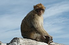
Barbary macaque

The Barbary macaque is found near Taliwin Mountain.
Photos gallery
-
 Location of Taliwin Mountain in Kendira Municipality
-
 Plate tectonics
Related topics
References
- Google Maps Archived December 06, 2017 at the Wayback Machine.
- Le Bois de Ben Haroun Archived September 23, 2016 at the Wayback Machine.
- Djazairess : Ruée sur les monts Takoucht et Adhrar N'fadh Archived December 06, 2017, at the Wayback Machine.
- Activités de developpement 2013 - fassmdz Archived December 06, 2017, at the Wayback Machine.
- Les montagnes de Kabylie sécurisées du jour au lendemain ? - Tamurt.info Archived December 21, 2017, at the Wayback Machine.
- (PDF) https://web.archive.org/web/20170329145903/http://www.pap-thecoastcentre.org/pdfs/Urbanisation-artificialisation%20des%20sols.pdf. Archived from the original (PDF) on 2017-03-29. {{citation
- Bulletin de la Société géologique de France Archived December 17, 2019, at the Wayback Machine.
- (PDF) https://web.archive.org/web/20160303234621/http://storage.lib.uchicago.edu/pres/2014/pres2014-0313.pdf. Archived from the original (PDF) in 2016-
- Entre les Babors et les Bibans : Haltes sur les monts de Sétif Archived December 06, 2017, at the Wayback Machine.
- (PDF) https://web.archive.org/web/20170202061718/http://biblio.univ-alger.dz/jspui/bitstream/1635/387/1/33166%20T4.pdf. Archived from the original (PDF) on 2017-02-02.
- (PDF) https://web.archive.org/web/20170202094957/http://193.194.83.98/jspui/bitstream/1635/178/1/22381.pdf. Archived from the original (PDF) on 2017-02-
- http://www.univ-bejaia.dz/dspace/bitstream/handle/123456789/5096/R%C3%A9gime%20alimentaire%20du%20Crapaud%20berb%C3%A8re%20%28Amietophrynus%20mauritanicus%29%20dans%20la%20r%C3%A9gion%20des%20Babors.pdf?sequence=1&isAllowed=y Archived 2020-03-11 on Wayback Machine.
- https://web.archive.org/web/20191224201909/http://www.lesoirdalgerie.com/articles/2016/10/10/article.php?sid=203108&cid=51. Archived from the original on 2019-12-24.
External links
| Tell Atlas | |
|---|---|
| Saharan Atlas | |
| Saharan massifs | |
| Peaks | |
