| Taniwel | |
|---|---|
| Kecamatan and village | |
 | |
| Coordinates: 2°50′54″S 128°26′24″E / 2.84833°S 128.44000°E / -2.84833; 128.44000 | |
| Country | Indonesia |
| Province | Maluku |
| Regency | West Seram |
| Time zone | UTC+8 (WITA) |
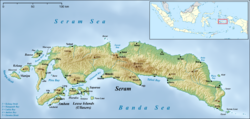
Taniwel is a village and kecamatan on the northwestern coast of the Indonesian island of Seram.
Geography
The Sapalewa River flows underground between the villages of Taniwel and Buria through the mountains of Hatu Toi Siwa, currently explored for about 3.7 kilometers. It is one of the largest underground rivers of the planet.
See also
- Niwelehu: village in Taniwel
References
- "Seram Island (map)". Indonesiatravelingguide.com. Archived from the original on June 9, 2015. Retrieved 8 June 2015.
- "Seram 2015". Scribd. Retrieved 2016-01-05.
- "Seram Speleologia 76 2016". Scribd. Retrieved 2017-09-20.
| Seram Island, Indonesia | |
|---|---|
| Settlements | |
| Geography | |
| Endemic fauna | |
| Native people and languages | |
This article about a location in Maluku Province is a stub. You can help Misplaced Pages by expanding it. |