Town in South Australia
| Tarlee South Australia | |||||||||||||||
|---|---|---|---|---|---|---|---|---|---|---|---|---|---|---|---|
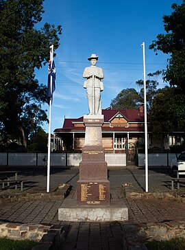
 Tarlee War Memorial Tarlee War Memorial | |||||||||||||||
 | |||||||||||||||
| Coordinates | 34°16′0″S 138°46′0″E / 34.26667°S 138.76667°E / -34.26667; 138.76667 | ||||||||||||||
| Population | 316 (SAL 2021) | ||||||||||||||
| Postcode(s) | 5411 | ||||||||||||||
| Elevation | 246 m (807 ft) | ||||||||||||||
| Location | 8 km (5 mi) south-east of Giles Corner | ||||||||||||||
| LGA(s) | District Council of Clare and Gilbert Valleys | ||||||||||||||
| Region | Mid North | ||||||||||||||
| State electorate(s) | Frome | ||||||||||||||
| Federal division(s) | Grey | ||||||||||||||
| |||||||||||||||
Tarlee is a town in South Australia. The origin of the name is uncertain, but it is thought to be a corruption of the name Tralee in Ireland. The township of Tarlee was advertised as readied for sale by auction in 1867. Tarlee is in the lower Mid North region where Horrocks Highway crosses the Gilbert River. It is approximately 8 km south of Giles Corner, where the Barrier Highway to Broken Hill diverges from the Horrocks Highway through the Clare Valley. At the 2016 census, Tarlee had a population of 302.
Tarlee was on the Peterborough railway line between Roseworthy junction and Burra. For a short period, Forrester's near Tarlee was the terminus as construction was authorised in two stages in the late 1860s.
The railway through Tarlee was closed in the 2000s.
The Tarlee institute building was opened in 1888.
Tarlee is in the District Council of Clare and Gilbert Valleys local government area, the South Australian House of Assembly electoral district of Frome and the Australian House of Representatives Division of Grey.
References
- Australian Bureau of Statistics (28 June 2022). "Tarlee (suburb and locality)". Australian Census 2021 QuickStats. Retrieved 28 June 2022.

- "Advertising". South Australian Weekly Chronicle. Vol. IX, no. 462. South Australia. 15 June 1867. p. 8. Retrieved 29 April 2021 – via National Library of Australia.
- Roseworthy to Forrester's Railway Act 1866-7 No. 24, Government Printer, 20 June 2008, retrieved 25 August 2015
- Forrester's to Burra Railway Act 1867 No. 20, Government Printer, 20 June 2008, retrieved 25 August 2015
- "Tarlee Institute streetview" (Map). Google Maps. Retrieved 25 August 2015.
| Towns and localities of the Clare and Gilbert Valleys Council | |
|---|---|
| Towns and localities |
|
| Geographic features | |
This South Australia geography article is a stub. You can help Misplaced Pages by expanding it. |