| This article does not cite any sources. Please help improve this article by adding citations to reliable sources. Unsourced material may be challenged and removed. Find sources: "Taskriout" – news · newspapers · books · scholar · JSTOR (August 2021) (Learn how and when to remove this message) |
| Taskriout | |
|---|---|
 | |
| Country | Algeria |
| Province | Béjaïa |
| Time zone | UTC+1 (GMT+1) |
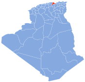
Taskriout is a commune in northern Algeria in the Béjaïa Province.
Geography
Taskriout is located in the southeast of the Bejaia Province, crossed by the National road N9, leading to Aït Smail, Kherrata, upwards Sétif. It consists of five villages; Aït Idriss, where Kefrida waterfall is situated, Aït Ali Oumhend, Aït Mbarek, Arrechah and Rif. Bordj Mira is the chief town. Taskriout appertain to the Darguina District.


36°34′N 5°15′E / 36.567°N 5.250°E / 36.567; 5.250
This article about a location in Béjaïa Province is a stub. You can help Misplaced Pages by expanding it. |
