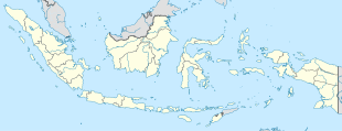
| Teluk Kuantan | |
|---|---|
  | |
| Coordinates: 0°31′47.13″S 101°34′19.42″E / 0.5297583°S 101.5720611°E / -0.5297583; 101.5720611 | |
| Country | |
| Province | Riau |
| Regency | Kuantan Singingi Regency |
| District | Kuantan Tengah District |
| Elevation | 171 ft (52 m) |
| Population | |
| • Total | 54,381 |
| Time zone | UTC+7 (Indonesia Western Standard Time) |
Teluk Kuantan (also known as Koto Taluk) is a town and the seat of Kuantan Singingi Regency, Riau province, Indonesia.
Climate
Teluk Kuantan has a tropical rainforest climate (Af) with heavy rainfall year-round.
| Climate data for Teluk Kuantan | |||||||||||||
|---|---|---|---|---|---|---|---|---|---|---|---|---|---|
| Month | Jan | Feb | Mar | Apr | May | Jun | Jul | Aug | Sep | Oct | Nov | Dec | Year |
| Mean daily maximum °C (°F) | 30.4 (86.7) |
31.0 (87.8) |
31.4 (88.5) |
31.7 (89.1) |
32.0 (89.6) |
31.7 (89.1) |
31.4 (88.5) |
31.4 (88.5) |
31.3 (88.3) |
31.2 (88.2) |
31.1 (88.0) |
30.6 (87.1) |
31.3 (88.3) |
| Daily mean °C (°F) | 26.3 (79.3) |
26.6 (79.9) |
26.9 (80.4) |
27.2 (81.0) |
27.4 (81.3) |
27.0 (80.6) |
26.6 (79.9) |
26.7 (80.1) |
26.8 (80.2) |
26.7 (80.1) |
26.7 (80.1) |
26.4 (79.5) |
26.8 (80.2) |
| Mean daily minimum °C (°F) | 22.2 (72.0) |
22.2 (72.0) |
22.5 (72.5) |
22.8 (73.0) |
22.8 (73.0) |
22.3 (72.1) |
21.9 (71.4) |
22.0 (71.6) |
22.3 (72.1) |
22.3 (72.1) |
22.4 (72.3) |
22.3 (72.1) |
22.3 (72.2) |
| Average precipitation mm (inches) | 217 (8.5) |
216 (8.5) |
246 (9.7) |
287 (11.3) |
224 (8.8) |
138 (5.4) |
135 (5.3) |
154 (6.1) |
218 (8.6) |
250 (9.8) |
298 (11.7) |
267 (10.5) |
2,650 (104.2) |
| Source: Climate-Data.org | |||||||||||||
References
- Badan Pusat Statistik, Jakarta, 28 February 2024, Kabupaten Kuantan Singingi Dalam Angka 2024 (Katalog-BPS 1102001.1409)
- "Climate: Teluk Kuantan". Climate-Data.org. Retrieved November 11, 2020.
This Riau location article is a stub. You can help Misplaced Pages by expanding it. |