Unincorporated community in Minnesota, United States Unincorporated community in Minnesota, United States
| Tenmile Corner | |
|---|---|
| Unincorporated community | |
  | |
| Coordinates: 43°58′43″N 94°25′45″W / 43.97861°N 94.42917°W / 43.97861; -94.42917 | |
| Country | United States |
| State | Minnesota |
| County | Watonwan |
| Elevation | 1,030 ft (310 m) |
| Time zone | UTC-6 (Central (CST)) |
| • Summer (DST) | UTC-5 (CDT) |
| Area code | 507 |
| GNIS feature ID | 654974 |
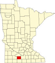
Tenmile Corner is an unincorporated community in Fieldon Township, Watonwan County, Minnesota, United States, located between Madelia and St. James on the intersection of highway 60 and highway 15. Its elevation is 1,030 feet.
Notes
- ^ "Tenmile Corner, Minnesota". Geographic Names Information System. United States Geological Survey, United States Department of the Interior.
- ^ "Tenmile Corner Populated Place Profile / Watonwan County, Minnesota Data".
| Municipalities and communities of Watonwan County, Minnesota, United States | ||
|---|---|---|
| County seat: St. James | ||
| Cities |  | |
| Townships | ||
| Unincorporated communities | ||
| Footnotes | ‡This populated place also has portions in an adjacent county or counties | |
This article about a location in Watonwan County, Minnesota is a stub. You can help Misplaced Pages by expanding it. |