| The Paps | |
|---|---|
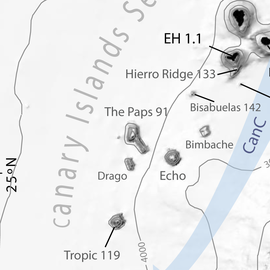
 Detail of a CISP's general bathymetric map centered on The Paps (Rivera et al. 2016). Detail of a CISP's general bathymetric map centered on The Paps (Rivera et al. 2016). | |
| Summit depth | 1,600 m |
| Height | 2,700 m |
| Location | |
| Location | North Atlantic |
| Group | Canary Islands Seamount Province |
| Coordinates | 25°55′N 20°18′W / 25.92°N 20.30°W / 25.92; -20.30 |
| Geology | |
| Age of rock | 91.1 ± 0.2 Ma |
The Paps is a Cretaceous seamount of the Atlantic Ocean, located in the Canary Islands Seamount Province (CISP). Featuring an elongated shape, it has a height of 2,700 metres.
Description
The seamount lies at about 25.92°N 20.30°W, about 300 km to the southwest of El Hierro. The age of the seamount has been estimated to 91.1 ± 0.2 million years. The seamount, whose top rises up to 1,600 m below sea level from a base that stands at 4,300 m below sea level, consists of a main block elongated along a N–S direction, featuring a secondary NW–SE ridge sprouting from the south east of the main edifice. It features a surface of 2,080 km.
Common features with the neighbouring Drago seamount, such an elongated shape and the presence of several small volcanic cones, suggest both seamounts may share a similar formation process.
References
- Citations
- ^ Palomino et al. 2016, p. 128.
- Marino et al. 2017, pp. 41–61.
- ^ van den Bogaard 2013.
- ^ Palomino et al. 2016, p. 126.
- Palomino et al. 2016, p. 138.
- Bibliography
- Marino, Egidio; González Sanz, Francisco Javier; Somoza, Luis; Lunar, Rosario; Vázquez, J. T.; Reyes, Jesús; Bellido, Eva (2017). "Strategic and rare elements in Cretaceous-Cenozoic cobalt-rich ferromanganese crusts from seamounts in the Canary Island Seamount Province (northeastern tropical Atlantic)". Ore Geology Reviews. 87: 41–61. Bibcode:2017OGRv...87...41M. doi:10.1016/j.oregeorev.2016.10.005.
- Palomino, Desirée; Vázquez, Juan-Tomás; Somoza, Luis; León, Ricardo; López-González, Nieves; Medialdea, Teresa; Fernández-Salas, Luis-Miguel; González, Francisco-Javier; Rengel, Juan Antonio (2016). "Geomorphological features in the southern Canary Island Volcanic Province: The importance of volcanic processes and massive slope instabilities associated with seamounts" (PDF). Geomorphology. 255: 125–139. Bibcode:2016Geomo.255..125P. doi:10.1016/j.geomorph.2015.12.016. hdl:10261/277037. ISSN 0169-555X.
- Rivera, J; Canals, M; Lastras, G; Hermida, N; Amblas, D; Arrese, B (2016). "Morphometry of Concepcion Bank: Evidence of Geological and Biological Processes on a Large Volcanic Seamount of the Canary Islands Seamount Province". PLoS ONE. 11 (5): e0156337. Bibcode:2016PLoSO..1156337R. doi:10.1371/journal.pone.0156337. PMC 4886973. PMID 27243626.
- van den Bogaard, Paul (2013). "The origin of the Canary Island Seamount Province - New ages of old seamounts". Scientific Reports. 3: 2107. Bibcode:2013NatSR...3E2107V. doi:10.1038/srep02107. PMC 3707084.