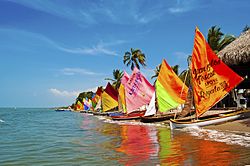
| Tolú | |
|---|---|
| Municipality and town | |
 | |
 Flag Flag Seal Seal | |
 Location of the municipality and town of Tolú in the Sucre Department of Colombia. Location of the municipality and town of Tolú in the Sucre Department of Colombia. | |
| Country | |
| Department | Sucre Department |
| Area | |
| • Municipality and town | 301.22 km (116.30 sq mi) |
| • Urban | 8.75 km (3.38 sq mi) |
| Elevation | 2 m (7 ft) |
| Population | |
| • Municipality and town | 32,922 |
| • Density | 110/km (280/sq mi) |
| • Urban | 26,401 |
| • Urban density | 3,000/km (7,800/sq mi) |
| Time zone | UTC-5 (Colombia Standard Time) |
Tolú is a small town in Sucre Department, northern Colombia on the Caribbean coast. The municipality has an area of 500 km. It is named after the Tolú, one the pre-Columbian indigenous people of the North Colombia lowlands.
The municipality of Tolú borders to the North with San Onofre, to the East with Toluviejo, to the South with Coveñas, Palmito and Sincelejo.
Notable people
- Héctor Rojas Herazo (1920–2002), novelist, poet and painter
See also
References
- Citypopulation.de
- Julian H. Steward, ed. (1948), Handbook of South American Indians, vol. 4, U.S. Government Printing Office, pp. 329–338
External links
- (in Spanish) Gobernacion de Sucre - Tolú
- (in Spanish) ToluCaribe.com - Recreación, Historia y Cultura de Tolú.
9°32′N 75°35′W / 9.533°N 75.583°W / 9.533; -75.583
| Municipalities in Sucre Department | ||
|---|---|---|
This Sucre Department location article is a stub. You can help Misplaced Pages by expanding it. |