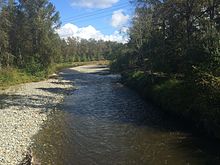
| Tolt River | |
|---|---|
 Map of the Tolt River highlighted in the Snohomish River watershed Map of the Tolt River highlighted in the Snohomish River watershed | |
| Location | |
| Country | United States |
| State | Washington |
| County | King |
| Physical characteristics | |
| Source | North Fork Tolt River |
| • coordinates | 47°41′44″N 121°49′14″W / 47.69556°N 121.82056°W / 47.69556; -121.82056 |
| Mouth | Snoqualmie River |
| • coordinates | 47°38′24″N 121°55′25″W / 47.64000°N 121.92361°W / 47.64000; -121.92361 |
| Discharge | |
| • location | USGS gage 12148500, near Carnation, WA |
| • average | 572 cu ft/s (16.2 m/s) |
| • minimum | 53 cu ft/s (1.5 m/s) |
| • maximum | 11,400 cu ft/s (320 m/s) |
The Tolt River is located in the western foothills of the Cascade Mountains in north central King County in the U.S. state of Washington. The river begins at the confluence of the North Fork Tolt and South Fork Tolt rivers. It flows southwest joining the Snoqualmie River near Carnation, Washington. The Tolt River watershed is part of the larger Snohomish River and Puget Sound drainage basin.
The South Fork Tolt watershed provides ~30% of the drinking water for Seattle area residents.
Name origin
The name Tolt comes from the Lushootseed village name tultxʷ or tulq.
See also

References
- ^ "Water Resources Data-Washington Water Year 2005; Snohomish River Basin" (PDF). USGS. Retrieved 5 August 2009.
- ^ U.S. Geological Survey Geographic Names Information System: Tolt River
- Bright, William (2004). Native American placenames of the United States. University of Oklahoma Press. p. 504. ISBN 978-0-8061-3598-4. Retrieved 11 April 2011.
External links
This King County, Washington state location article is a stub. You can help Misplaced Pages by expanding it. |
This article related to a river in the state of Washington is a stub. You can help Misplaced Pages by expanding it. |