| This article needs additional citations for verification. Please help improve this article by adding citations to reliable sources. Unsourced material may be challenged and removed. Find sources: "Tonglu, West Bengal" – news · newspapers · books · scholar · JSTOR (July 2013) (Learn how and when to remove this message) |
| Tonglu | |
|---|---|
| village | |
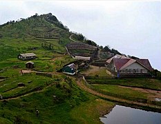
 The trekkers' hut at Tonglu The trekkers' hut at Tonglu | |
  | |
| Coordinates: 27°02′N 88°05′E / 27.03°N 88.09°E / 27.03; 88.09 | |
| Country | |
| State | West Bengal |
| District | Darjeeling |
| Government | |
| • Body | Gram panchayat |
| Elevation | 3,070 m (10,070 ft) |
| Languages | |
| • Official | Nepali Bengali English |
| Time zone | UTC+5:30 (IST) |
| ISO 3166 code | IN-WB |
Tonglu (3036 m above mean sea level) is one of the higher peaks of the Singalila Ridge and a small settlement inside the Singalila National Park in the Darjeeling subdivision, Darjeeling district in the state of West Bengal in India near the India - Nepal border. It is a roadside halt along the trekking route from Manebhanjan to Sandakphu. It has a number of guest houses and homestays for faring trekkers and tourists on their way to Sandakphu.
It was also known as Tonglo in the 1800s. Sir Joseph Dalton Hooker carried out many plant hunting expeditions in Darjeeling and Sikkim.
Geography
5milesSIK K IMNEP A L Rammam
River River Rangeet Singalila Ridge Senchal
Wildlife SanctuaryNP
National
ParkNP
CT: census town, R: rural/ urban centre, N: neighbourhood, H: hill centre, NP: national park/ wildlife sanctuary, TE: tea estate, TA: tourist attraction
Abbreviations used in names – TG for Tea Garden (town/village), TE for Tea Estate
Owing to space constraints in the small map, the actual locations in a larger map may vary slightly
Location
Tonglu is located at 27°02′N 88°05′E / 27.03°N 88.09°E / 27.03; 88.09.
Area overview
The map alongside shows the northern portion of the Darjeeling Himalayan hill region. Kangchenjunga, which rises with an elevation of 8,586 metres (28,169 ft) is located further north of the area shown.Sandakphu, rising to a height of 3,636 metres (11,929 ft), on the Singalila Ridge, is the highest point in West Bengal. In Darjeeling Sadar subdivision 61% of the total population lives in the rural areas and 39% of the population lives in the urban areas. There are 78 tea gardens/ estates (the figure varies slightly according to different sources), producing and largely exporting Darjeeling tea in the district. It engages a large proportion of the population directly/ indirectly. Some tea gardens were identified in the 2011 census as census towns or villages. Such places are marked in the map as CT (census town) or R (rural/ urban centre). Specific tea estate pages are marked TE.
Note: The map alongside presents some of the notable locations in the subdivision. All places marked in the map are linked in the larger full screen map.
Gallery
References
- "Letter from Major G.E.[George Ernest] Bulger to [Sir Joseph Dalton Hooker]; from Secunderabad, India; 6 Dec 1868; two page letter comprising two images; folio 168". jstor.org. Retrieved 18 December 2014.
{{cite journal}}: Cite journal requires|journal=(help) - "Wild Flowers of Mount Tonglo, Sikkim, India by Marianne North". Art UK. Retrieved 18 December 2014.
- J.S. Gamble Manual Of Indian Timbers&pg=PA472 sigPAwAAQBAJ, p. 472, at Google Books
- Das, A.P.; Ghosh, Chandra (March 2011). "Plant wealth of Darjiling and Sikkim Himalayas vis-à-vis Conservation". NBU Journal of Plant Sciences. 5 (1). University of Bengal: 25–33. doi:10.55734/NBUJPS.2011.v05i01.004. S2CID 251454744. Retrieved 18 December 2014.
- "Yahoo maps location of Tonglu". Yahoo maps. Retrieved 7 December 2008.
- Gurung, H. & Shrestha, R. K. (1994). Nepal Himalaya Inventory. Kathmandu: Ministry of Tourism and Civil Aviation.
- "Sandakphu-Phalut Trek". Himalayan High. Retrieved 21 March 2020.
- "Darjeeling". District Profile - General Information. District administration. Retrieved 21 March 2020.
- "District Statistical Handbook 2013 Darjeeling". Tables 2.2, 2.4b. Department of Planning and Statistics, Government of West Bengal. Retrieved 21 March 2020.
- "Darjeeling Tea". District administration. Retrieved 21 March 2020.
- "2011 Census – Primary Census Abstract Data Tables". West Bengal – District-wise. Registrar General and Census Commissioner, India. Retrieved 21 March 2020.
External links
- About Tonglu from North Bengal Tourism
This article about a location in the Darjeeling district of West Bengal is a stub. You can help Misplaced Pages by expanding it. |

