| Torres Airport Aeroporto de Torres | |||||||||||
|---|---|---|---|---|---|---|---|---|---|---|---|
 | |||||||||||
| Summary | |||||||||||
| Airport type | Public | ||||||||||
| Operator | |||||||||||
| Serves | Torres | ||||||||||
| Time zone | BRT (UTC−03:00) | ||||||||||
| Elevation AMSL | 9 m / 30 ft | ||||||||||
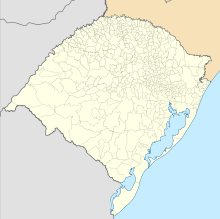
| Coordinates | 29°24′54″S 049°48′36″W / 29.41500°S 49.81000°W / -29.41500; -49.81000 | ||||||||||
| Map | |||||||||||
  | |||||||||||
| Runways | |||||||||||
| |||||||||||
| Sources: ANAC, DECEA | |||||||||||
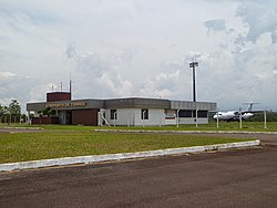
Torres Airport (IATA: TSQ, ICAO: SSTE), formerly SBTR, is the airport serving Torres, Brazil.
It is operated by Infraero.
History
On July 14, 2024 the State of Rio Grande do Sul signed a contract of operation with Infraero. Previously the airport was operated by DAP.
Airlines and destinations
No scheduled flights operate at this airport.
Access
The airport is located 15 km (9 mi) from downtown Torres.
See also
References
- "Aeródromos". ANAC (in Portuguese). 29 June 2020. Retrieved 11 February 2021.
- "TORRES (SSTE)". DECEA (in Portuguese). Retrieved 27 September 2023.
- "Governo do Estado confirma operação da Infraero para ampliar voos nos aeroportos de Canela e Torres". Governo do Estado do Rio Grande do Sul (in Portuguese). 12 July 2024. Retrieved 14 July 2024.
External links
- Airport information for SSTE at Great Circle Mapper. Source: DAFIF (effective October 2006).
- Current weather for SSTE at NOAA/NWS
- Accident history for TSQ at Aviation Safety Network
| Airports in Rio Grande do Sul | |
|---|---|
| Lists of airports | |
|---|---|
| By IATA code | |
| By ICAO code | |
| By continent | |
| Busiest airports | |
| Other lists | |
| Brazil articles | |||||||
|---|---|---|---|---|---|---|---|
| History | |||||||
| Geography | |||||||
| Politics | |||||||
| Economy |
| ||||||
| Society |
| ||||||