| Tosa-Kitagawa Station 土佐北川駅 | |||||
|---|---|---|---|---|---|
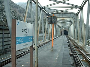
 Tosa-Kitagawa Station in 2007 Tosa-Kitagawa Station in 2007 | |||||
| General information | |||||
| Location | Kusunoki, Otoyo, Nagaoka-gun, Kōchi-ken 789-0324 Japan | ||||
| Coordinates | 33°42′53″N 133°41′11″E / 33.714757°N 133.686333°E / 33.714757; 133.686333 | ||||
| Operated by | |||||
| Line(s) | ■ Dosan Line | ||||
| Distance | 93.3 km from Tadotsu | ||||
| Platforms | 1 island platform | ||||
| Tracks | 2 | ||||
| Construction | |||||
| Accessible | No - steps lead up to platform | ||||
| Other information | |||||
| Station code | D33 | ||||
| History | |||||
| Opened | 1 October 1960 (1960-10-01) | ||||
| Passengers | |||||
| FY2019 | 4 | ||||
| |||||
Tosa-Kitagawa Station (土佐北川駅, Tosa-Kitagawa-eki) is a passenger railway station located in the town of Ōtoyo, Nagaoka District, Kōchi Prefecture, Japan. It is operated by JR Shikoku and has the station number "D33".
Lines
The station is served by the JR Shikoku Dosan Line and is located 93.3 km from the beginning of the line at Tadotsu.
Layout
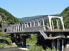
The station, which is unmanned, consists of a narrow island platform serving two tracks all mounted on an iron bridge spanning the Ananai River. From both the north and south ends of the bridge, stairs lead up to a pedestrian walkway along the length of the bridge which gives access to the platform. At an intermediate landing up the steps on the south side, a waiting room has been established.
-
Station entrance on the north side of the bridge. The stairs lead to a walkway which runs along the length of the bridge.
-
Access to the entrance on the south side of the bridge is via a gravel footpath. A public telephone call box has been installed. A toilet building can also be seen in the background.
-
 The stairs on the south side lead up to the walkway along the bridge.
-
At a landing under the bridge on the south side, a waiting room has been installed.
Adjacent stations
| « | Service | » | ||
|---|---|---|---|---|
| Dosan Line | ||||
| Ōsugi | - | Kakumodani | ||
History
The station opened on 1 October 1960 on the existing Dosan Line but at a different location further to the south. After track re-alignment works, the station was moved to its present location on 3 March 1986. At this time the station was operated by Japanese Government Railways, later becoming Japanese National Railways (JNR). With the privatization of JNR on 1 April 1987, control of the station passed to JR Shikoku.
Surrounding area
See also
References
- "Shikoku Railway Route Map" (PDF). JR Shikoku. Retrieved 25 November 2017.
- ^ "土佐北川" [Tosa-Kitagawa]. hacchi-no-he.net. Retrieved 17 December 2017.
- ^ Ishino, Tetsu; et al., eds. (1998). 停車場変遷大事典 国鉄・JR編 [Station Transition Directory – JNR/JR] (in Japanese). Vol. II. Tokyo: JTB Corporation. p. 666. ISBN 4-533-02980-9.
- "Tosa-Kitagawa Station Timetable" (PDF). JR Shikoku. Retrieved 17 December 2017.
- "土佐北川駅" [Tosa-Kitagawa Station]. shikoku.org.uk. Retrieved 17 December 2017.
- Ishino, Tetsu; et al., eds. (1998). 停車場変遷大事典 国鉄・JR編 [Station Transition Directory – JNR/JR] (in Japanese). Vol. I. Tokyo: JTB Corporation. pp. 217–218. ISBN 4-533-02980-9.
External links
- JR Shikoku timetable (in Japanese)

