| Totem Lake | |
|---|---|
| Lake Wittenmyer, Lake Watstine, Mudd Lake (historical) | |
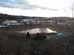
 Totem lake as seen from a hill to its north Totem lake as seen from a hill to its north | |
  | |
| Location | Kirkland, Washington, U.S. |
| Coordinates | 47°42′39″N 122°10′34″W / 47.71083°N 122.17611°W / 47.71083; -122.17611 |
| Type | Kettle lake |
| Primary outflows | Juanita Creek |
| Surface area | 2 acres (0.81 ha) |
| Surface elevation | 131 feet (40 m) |
| References | coordinates and elevation from U.S. Geological Survey |
Totem Lake is a two-acre (0.8 ha) lake in the northwest United States, located in Kirkland, Washington, a suburb east of Seattle, at the head of a branch of Juanita Creek, inside the Juanita Creek Basin. A Kirkland neighborhood and retail/residential development are named for the lake.
A 17.2-acre (7.0 ha) park completely surrounds the lake, bordered by the Cross Kirkland Corridor linear park and trail. The lake has had other names including Lake Wittenmyer, Lake Watstine, Mudd Lake, and an original Native American name which has been lost.
References
- "Lakes of King County", Official website, King County
- U.S. Geological Survey Geographic Names Information System: Totem Lake
- Juanita Creek Watershed Map, City of Kirkland Public Works Department
- United States Geological Survey 1:24,000 topographic quad map "Kirkland, WA" 1976 ed.
- Melissa English; Doreen Gavin (February 26, 2015). "How to treat stormwater in urban areas — like Totem Lake". Daily Journal of Commerce. Portland, Oregon.
- "Totem Lake Park". City of Kirkland official website. Department of Parks and Community Services. Retrieved January 19, 2021.
- Phelps, Matt (January 12, 2011). "The history of Kirkland's Totem Lake Malls". Kirkland Reporter. Seattle – via Seattle Post-Intelligencer.
This King County, Washington state location article is a stub. You can help Misplaced Pages by expanding it. |