| Towers of the Virgin | |
|---|---|
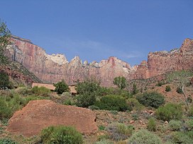
 Towers of the Virgin, with the Zion Human History Museum in left front, August 2007 Towers of the Virgin, with the Zion Human History Museum in left front, August 2007 | |
| Highest point | |
| Elevation | 7,340 ft (2,240 m) |
| Geography | |
The Towers of the Virgin is a series of several lofty sandstone monoliths on the west side of Zion Canyon in Zion National Park in Washington County, Utah, United States.
Description
The peaks of the Towers of the Virgin (from south to northeast) include: The Sundial, The Witch Head, Broken Tooth, Rotten Tooth, Altar of Sacrifice, Meridian Tower, Bee Hive, and The Sentinel. The Towers of the Virgin have also been known as Rock Rovers' Land, Temples of the Virgen, and Tu'-Mu-Ur-Ru-Gwait'Si-Gaip Tu-Weap' and were included in the original boundaries of what was known as Zion National Monument.
Climate
Spring and fall are the most favorable seasons to visit the Towers of the Virgin. According to the Köppen climate classification system, it is located in a cold semi-arid climate zone, which is defined by the coldest month having an average mean temperature below 32 °F (0 °C), and at least 50% of the total annual precipitation being received during the spring and summer. This desert climate receives less than 10 inches (250 millimeters) of annual rainfall, and snowfall is generally light during the winter.
See also
References
- ^ U.S. Geological Survey Geographic Names Information System: Towers of the Virgin
- "DecisionCard_10252.pdf" (PDF). geonames.usgs.gov. United States Geological Survey. 4 April 1934. Retrieved 14 July 2021.
- "DecisionCard_09907.pdf" (PDF). geonames.usgs.gov. United States Geological Survey. 4 April 1934. Retrieved 14 July 2021.
- "DecisionCard_10113.pdf" (PDF). geonames.usgs.gov. United States Geological Survey. 4 April 1934. Retrieved 14 July 2021.
- "DecisionCard_09914.pdf" (PDF). geonames.usgs.gov. United States Geological Survey. 4 April 1934. Retrieved 14 July 2021.
- "DecisionCard_10422.pdf" (PDF). geonames.usgs.gov. United States Geological Survey. 4 April 1934. Retrieved 14 July 2021.
- Williams, Carter (19 November 2019). "How Zion National Park helped put Utah at 'center of scenic America' 100 years ago". ksl.com. Salt Lake City: Deseret Digital Media. Retrieved 14 July 2021.
- "Zion National Park, Utah, USA - Monthly weather forecast and Climate data". Weather Atlas. Archived from the original on January 27, 2019. Retrieved 31 August 2020.
External links
![]() Media related to Towers of the Virgin (Zion National Park) at Wikimedia Commons
Media related to Towers of the Virgin (Zion National Park) at Wikimedia Commons
37°14′00″N 113°01′03″W / 37.23332°N 113.01744°W / 37.23332; -113.01744
This article about a location in Utah is a stub. You can help Misplaced Pages by expanding it. |