| This article needs additional citations for verification. Please help improve this article by adding citations to reliable sources. Unsourced material may be challenged and removed. Find sources: "Traill's Pass" – news · newspapers · books · scholar · JSTOR (July 2021) (Learn how and when to remove this message) |
| Trail's Pass | |
|---|---|
 | |
| Elevation | 5,312 m (17,428 ft) |
| Location | Uttarakhand, India |
| Range | Himalaya |
| Coordinates | 30°19′10″N 80°01′40″E / 30.31944°N 80.02778°E / 30.31944; 80.02778 |
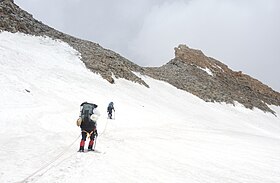
Pindari Kanda Traill's Pass (el. 5,300 m or 17,400 ft) is a mountain pass through the Himalayas located between Nanda Devi and Nanda Kot peaks, in the districts of Pithoragarh and Bageshwar in Uttarakhand state, India. The pass is situated at the end of Pindari glacier and links Pindari valley to Milam Valley (Lawan Gad).
Difficulty of passage
The pass is considered very difficult to cross. It was reached in 1830 by G.W. Traill, the first British Deputy Commissioner of Kumaon division, for whom it was named. In 1926, it was crossed by Hugh Ruttledge.
Since 1830, Trail's pass has been attempted by more than ninety teams; As of October 2021, only twenty teams are known to have succeeded, most recently a group from Uttarakhand in October 2021.
References
- Kapadia, Harish (1 January 1999). Across Peaks and Passes in Garhwal Himalaya. India: Indus Publishing Company. p. 57. ISBN 978-81-7387-097-2. Retrieved 5 August 2009.
- Kapadia, Harish (1 January 1999). Across Peaks and Passes in Garhwal Himalaya. India: Indus Publishing Company. pp. 59–60. ISBN 978-81-7387-097-2. Retrieved 5 August 2009.
- "Successful Crossing of Traill's Pass".
This Indian location article is a stub. You can help Misplaced Pages by expanding it. |
This mountain, mountain range, or peak related article is a stub. You can help Misplaced Pages by expanding it. |