| Trinity Mountain | |
|---|---|
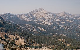
 Trinity Mountain during the Elk Complex Fire Trinity Mountain during the Elk Complex Fire | |
| Highest point | |
| Elevation | 9,451 ft (2,881 m) |
| Prominence | 2,371 ft (723 m) |
| Isolation | 11.63 mi (18.72 km) |
| Coordinates | 43°35′56″N 115°25′44″W / 43.5987842°N 115.4289782°W / 43.5987842; -115.4289782 |
| Geography | |
 | |
| Parent range | Boise Mountains |
| Topo map | USGS Trinity Mountain |
| Climbing | |
| Easiest route | Hiking, class 1 |
Trinity Mountain is the highest point in the Trinity Mountains, a subrange of the Boise Mountains in Boise National Forest, Idaho with a summit elevation of 9,451 feet (2,881 m). It is located 11.63 miles (18.72 km) from Steel Mountain, its line parent, giving it a prominence of 2,371 feet (723 m). Trinity Mountain is within the watershed of the South Fork Boise River.
References
- ^ "Trinity Mountain, Idaho". Peakbagger.com. Retrieved December 27, 2014.
- "Trinity Mountain". Geographic Names Information System. United States Geological Survey, United States Department of the Interior. Retrieved December 27, 2014.
- Boise National Forest (Map). 1:126720. U.S. Forest Service. 2012.
This Elmore County, Idaho state location article is a stub. You can help Misplaced Pages by expanding it. |