 | |
 | |
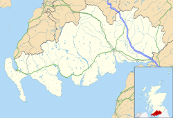
| Location | near Gatehouse of Fleet, Dumfries and Galloway |
|---|---|
| Coordinates | 54°52′43.97″N 4°12′3.42″W / 54.8788806°N 4.2009500°W / 54.8788806; -4.2009500 |
| OS grid reference | NX58895601 |
| Type | hillfort |
| Length | 29 m (95 ft) |
| Width | 17 m (56 ft) |
| Area | 0.04 ha (0.099 acres) (summit enclosure) |
| History | |
| Founded | c. 600 AD |
| Abandoned | early 7th century |
| Site notes | |
| Excavation dates | 1960, 2012 |
| Scheduled monument | |
| Designated | 19 January 1926 |
| Reference no. | SM1100 |
Trusty's Hill is a small vitrified hillfort about a mile to the west of the present-day town of Gatehouse of Fleet, in the parish of Anwoth in the Stewartry district of Dumfries and Galloway.
The site is notable for a carved Pictish stone located near the entrance to the fort, one of only a handful of such stones found outside the core Pictish heartland of North-East Scotland. A 2012 archaeological investigation found evidence of feasting and high-status metalworking at the site, and what has been interpreted as a constructed ceremonial processional route. Together these have led to speculation that the site might have been an important centre or location of royal inaugurations for a Brythonic kingdom centred in Galloway and South-West Scotland, circa 600 AD — perhaps to be identified with the elusive north British kingdom of Rheged, which gained greatest prominence under its legendary leader Urien at a similar time in the late 6th century before apparently utterly disappearing in the early 7th century.
Description and history
-
 1856 drawing of the symbols on the stone. To the left is a double disc with Z-rod, to the right a fish monster and a sword. The head with antennae is a 19th-century addition.
-
 The stone in 2015, protected by an iron grille.
Further reading
- Toolis, Ronan; Bowles, Christopher (2017). The Lost Dark Age Kingdom of Rheged: the Discovery of a Royal Stronghold at Trusty’s Hill, Galloway. Oxford: Oxbow Books. ISBN 9781785703119. (Publisher's website; JSTOR; Google Books). Official published report of the 2012 investigation.
- Toolis, Ronan; Bowles, Christopher (24 October 2012). "Excavation and Survey of Trusty's Hill – Summary Report" (PDF). The Galloway Picts Project. illustrated by Gillian McSwan & Fiona Jackson. Retrieved 5 December 2024.
External links
- Historic Environment Scotland. "Trusty's Hill, Anwoth (63641)". Canmore.
- Ronan Toolis (May 2017), Rheged rediscovered: uncovering a lost British kingdom in Galloway, Current Archaeology, 327
- James Hoare (31 January 2017), The Lost Kingdom of Rheged: What the Trusty’s Hill dig can tell us about Celtic Britain, History Answers
- Discovery of Lost Dark Age Kingdom In Galloway, Guard Archaeology, 15 January 2017
- The Galloway Picts Project, Excavation website
- A Window on Dark Age Galloway, Gatehouse of Fleet community and visitor website, Gatehouse Development Initiative.
| Hen Ogledd | |
|---|---|
| Kingdoms or Territories | |
| Important Places | |
| People | |
| Scotland in the Middle Ages | ||
|---|---|---|
| Eras |  | |
| Early Realms | ||
| Topics | ||
| Events | ||
| Places | ||
| Institutions | ||
| Related articles | ||