| Tufs et calcaires de Rosan | |
|---|---|
| Stratigraphic range: Katian-Hirnantian (Kralodvorian-Kosovian) ~450–443.7 Ma PreꞒ Ꞓ O S D C P T J K Pg N | |
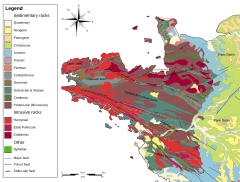
 Geologic map of the Armorican Massif Geologic map of the Armorican Massif | |
| Type | Formation |
| Lithology | |
| Primary | Tuff, limestone |
| Other | Pillow lava, claystone, sandstone |
| Location | |
| Coordinates | 48°18′N 4°12′W / 48.3°N 4.2°W / 48.3; -4.2 |
| Approximate paleocoordinates | 70°18′S 53°54′E / 70.3°S 53.9°E / -70.3; 53.9 |
| Region | Finistère |
| Country | |
| Extent | Armorican Massif |
| Type section | |
| Named for | Rosan |
  | |
The Tufs et calcaires de Rosan is a geologic formation in France. It preserves fossils dating back to the Katian to Hirnantian (Kralodvorian to Kosovian in the regional stratigraphy) stages of the Late Ordovician period.
Fossil content
The formation has provided fossils of:
Strophomenata
Rhynchonellata
- Porambonites sp.
- Eoanastrophia sp.
- Rostricellula sp.
- ?Dalmanella sp.
- Bancroftina sp.
- Nicolella sp.
- Retrorsirostra sp.
- Ptychopleurella sp.
- Dolerorthis sp.
- Mcewanella sp.
- Aberia sp.
- ?Rhactorthis sp.
See also
References
- ^ Tufs et calcaires de Rosan at Fossilworks.org
- Melou, 1990
Bibliography
- M. Melou. 1990. Brachiopodes articules de la coupe de l'ile de Rosan (Crozon, Finistere); formation des tufs et calcaires de Rosan (Caradoc-Ashgill). Géobios 23(5):539-579