| This article needs additional citations for verification. Please help improve this article by adding citations to reliable sources. Unsourced material may be challenged and removed. Find sources: "Tung Tsz" – news · newspapers · books · scholar · JSTOR (February 2022) (Learn how and when to remove this message) |

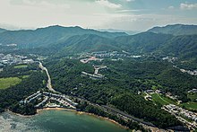
Tung Tsz (Chinese: 洞梓), sometimes transliterated as Tung Tsai, is an area near Shuen Wan (Plover Cove) in the Tai Po District of the New Territories, Hong Kong, under the hills of Pat Sin Leng. The area is mainly rural and has a few villages. The campus of The Education University of Hong Kong and the campsite of Tung Tsz Scout Centre for The Scout Association of Hong Kong are also located in the area.
Tung Tsz Road goes through the village connected by Ting Kok Road.
Administration
Tseng Tau, including A Shan and Tung Tsz, is a recognized village under the New Territories Small House Policy. For electoral purposes, Tung Tsz is part of the Shuen Wan constituency of the Tai Po District Council. It was formerly represented by So Tat-leung, who was elected in the local elections until October 2021.
History
At the time of the 1911 census, the population of Tung Tsai was 43. The number of males was 14.
See also
References
- "List of Recognized Villages under the New Territories Small House Policy" (PDF). Lands Department. September 2009.
- "Recommended District Council Constituency Areas (Tai Po District)" (PDF). Electoral Affairs Commission. Retrieved 27 November 2021.
- "North District Council - North DC Members". District Council. Retrieved 27 November 2021.
- Hase, Patrick (1996). "Traditional Life in the New Territories: The Evidence of the 1911 and 1921 Censuses" (PDF). Journal of the Royal Asiatic Society Hong Kong Branch. 36: 80. ISSN 1991-7295.
External links
22°28′27″N 114°11′50″E / 22.4743°N 114.1971°E / 22.4743; 114.1971
This Hong Kong location article is a stub. You can help Misplaced Pages by expanding it. |