Census-designated place in Arkansas, United States
| Uniontown, Arkansas | |
|---|---|
| Census-designated place | |
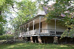
 Slack-Comstock-Marshall Farm Slack-Comstock-Marshall Farm | |
  | |
| Coordinates: 35°35′04″N 94°26′39″W / 35.58444°N 94.44417°W / 35.58444; -94.44417 | |
| Country | United States |
| State | Arkansas |
| County | Crawford |
| Elevation | 866 ft (264 m) |
| Population | |
| • Total | 112 |
| Time zone | UTC-6 (Central (CST)) |
| • Summer (DST) | UTC-5 (CDT) |
| ZIP code | 72955 |
| Area code | 479 |
| GNIS feature ID | 2805689 |
Uniontown is an unincorporated community and census-designated place (CDP) in Crawford County, Arkansas, United States. It is located on Arkansas Highway 220 near the Oklahoma border, 4.5 miles (7.2 km) west-northwest of Cedarville. Uniontown has a post office with ZIP code 72955.
It was first listed as a CDP in the 2020 census with a population of 112.
History
The first permanent settlement at Uniontown was made in the 1840s by the Howell family. A post office has been in operation at Uniontown since 1881.
Slack-Comstock-Marshall Farm, which is listed on the National Register of Historic Places, is located in the community.
Demographics
| Census | Pop. | Note | %± |
|---|---|---|---|
| 2020 | 112 | — | |
| U.S. Decennial Census 2020 | |||
2020 census
| Race / Ethnicity (NH = Non-Hispanic) | Pop 2020 | % 2020 |
|---|---|---|
| White alone (NH) | 91 | 81.25% |
| Black or African American alone (NH) | 0 | 0.00% |
| Native American or Alaska Native alone (NH) | 7 | 6.25% |
| Asian alone (NH) | 2 | 1.79% |
| Pacific Islander alone (NH) | 0 | 0.00% |
| Some Other Race alone (NH) | 0 | 0.00% |
| Mixed Race or Multi-Racial (NH) | 11 | 9.82% |
| Hispanic or Latino (any race) | 1 | 0.89% |
| Total | 112 | 100.00% |
References
- ^ U.S. Geological Survey Geographic Names Information System: Uniontown, Arkansas
- ZIP Code Lookup Archived June 15, 2011, at the Wayback Machine
- "Uniontown CDP, Arkansas". United States Census Bureau. Retrieved April 7, 2022.
- History of Benton, Washington, Carroll, Madison, Crawford, Franklin, and Sebastian Counties, Arkansas. Higginson Book Company. 1889. p. 554.
- "Post Offices". Jim Forte Postal History. Retrieved February 6, 2018.
- "National Register Information System". National Register of Historic Places. National Park Service. March 13, 2009.
- "Decennial Census of Population and Housing by Decades". US Census Bureau.
- ^ "P2 Hispanic or Latino, and Not Hispanic or Latino by Race – 2020: DEC Redistricting Data (PL 94-171) – Uniontown CDP, Arkansas". United States Census Bureau.
| Municipalities and communities of Crawford County, Arkansas, United States | ||
|---|---|---|
| County seat: Van Buren | ||
| Cities |  | |
| Towns | ||
| CDPs | ||
| Other unincorporated communities | ||
| Ghost towns | ||
This article about a location in Crawford County, Arkansas is a stub. You can help Misplaced Pages by expanding it. |