You can help expand this article with text translated from the corresponding article in German. (June 2014) Click for important translation instructions.
|
| Braunschweig-Völkenrode | |
|---|---|
| Quarter of Braunschweig | |
 Church in Völkenrode. Church in Völkenrode. | |
 Coat of arms Coat of arms | |
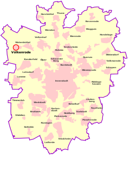
Location of Völkenrode within Braunschweig
 | |
  | |
| Coordinates: 52°18′17″N 10°26′33″E / 52.30472°N 10.44250°E / 52.30472; 10.44250 | |
| Country | Germany |
| State | Lower Saxony |
| District | urban district |
| City | Braunschweig |
| Population | |
| • Total | 1,731 |
| Time zone | UTC+01:00 (CET) |
| • Summer (DST) | UTC+02:00 (CEST) |
| Postal codes | 38112 |
| Dialling codes | 0531 |
| Vehicle registration | BS |
Völkenrode is a quarter (Stadtteil) of Braunschweig, Lower Saxony, Germany. Formerly a municipality in its own right and part of the district of Braunschweig, it was incorporated into the city of Braunschweig in 1974. Today, it is part of the Stadtbezirk Lehndorf-Watenbüttel.
During the Second World War, it was home to the Luftfahrtforschungsanstalt (Aeronautical Research Institute, LFA), a secret facility for airframe, aeroengine, and aircraft weapons testing.
Völkenrode, and the LFA, were visited postwar by the British Ministry of Aircraft Production survey team, headed by Sir Roy Fedden. Today, the Physikalisch-Technische Bundesanstalt and the former Federal Agricultural Research Centre are located on the former LFA site.
References
- "Kreisfreie Stadt Braunschweig" (PDF) (in German). statistik.niedersachsen.de.
- Christopher, John. The Race for Hitler's X-Planes (The Mill, Gloucestershire: History Press, 2013), pp.25 and 40, and map p.26.
- Christopher, pp.9-10.
External links
- Website (in German)
This Braunschweig location article is a stub. You can help Misplaced Pages by expanding it. |