Commune in Pays de la Loire, France
| Vaiges | |
|---|---|
| Commune | |
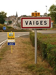
 The road into Vaiges The road into Vaiges | |
| Location of Vaiges | |
  | |
| Coordinates: 48°02′29″N 0°28′29″W / 48.0414°N 0.4747°W / 48.0414; -0.4747 | |
| Country | France |
| Region | Pays de la Loire |
| Department | Mayenne |
| Arrondissement | Mayenne |
| Canton | Meslay-du-Maine |
| Government | |
| • Mayor (2020–2026) | Régis Lefeuvre |
| Area | 36.26 km (14.00 sq mi) |
| Population | 1,166 |
| • Density | 32/km (83/sq mi) |
| Time zone | UTC+01:00 (CET) |
| • Summer (DST) | UTC+02:00 (CEST) |
| INSEE/Postal code | 53267 /53480 |
| Elevation | 67–126 m (220–413 ft) (avg. 91 m or 299 ft) |
| French Land Register data, which excludes lakes, ponds, glaciers > 1 km (0.386 sq mi or 247 acres) and river estuaries. | |
Vaiges (French pronunciation: [vɛʒ]) is a commune in the Mayenne department and Pays de la Loire region of France.
Geography
The river Vaige forms part of the commune's northern border, then traverses the commune's territory from north to south before forming part of its south-western border.
See also
References
- "Répertoire national des élus: les maires" (in French). data.gouv.fr, Plateforme ouverte des données publiques françaises. 13 September 2022.
- "Populations légales 2021" (in French). The National Institute of Statistics and Economic Studies. 28 December 2023.
This Mayenne geographical article is a stub. You can help Misplaced Pages by expanding it. |