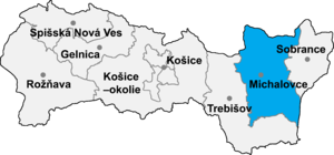
Veľké Raškovce (Slovak pronunciation: [ˈʋeʎkeː ˈraʂkɔwtse]; Hungarian: Nagyráska) is a village and municipality in Michalovce District in the Kosice Region of eastern Slovakia.
History
In historical records, the village was first mentioned in 1332.
Geography
The village lies at an altitude of 104 metres and covers an area of 11.998 km. The municipality has a population of about 350 people.
Culture
The village has a cultural centre, a football pitch and a recreational area with fish ponds.
Gallery
-
 Reformed church in Veľké Raškovce
-
Reformed church in Veľké Raškovce
-
Dedication plaque on reformed church in Veľké Raškovce (est. 1806)
-
Roman Catholic church of the Ascension of the Lord in Veľké Raškovce
-
Memorial to victims of World War II
-
Old millstone from the village on public display
-
 Current municipal office and village hall
-
Former municipal office (now used for other public purposes)
-
Kindergarten of the municipality
-
 Grocery shop and village pub
-
 "Old Laborec" fish pond next to the village
-
 "Old Laborec" fish pond next to the village
-
 "Old Laborec" fish pond next to the village
-
Funeral home at the municipality's cemetery
-
 Pumping station regulating water levels in the Duša river canal
See also
- List of municipalities and towns in Michalovce District
- List of municipalities and towns in Slovakia
External links
48°33′N 21°55′E / 48.550°N 21.917°E / 48.550; 21.917
This Michalovce District geography article is a stub. You can help Misplaced Pages by expanding it. |