| Vestbygd Borhaug | |
|---|---|
| Village | |
  | |
| Coordinates: 58°05′59″N 06°35′13″E / 58.09972°N 6.58694°E / 58.09972; 6.58694 | |
| Country | Norway |
| Region | Southern Norway |
| County | Agder |
| District | Lister |
| Municipality | Farsund |
| Area | |
| • Total | 0.9 km (0.3 sq mi) |
| Elevation | 11 m (36 ft) |
| Population | |
| • Total | 1,123 |
| • Density | 1,248/km (3,230/sq mi) |
| Time zone | UTC+01:00 (CET) |
| • Summer (DST) | UTC+02:00 (CEST) |
| Post Code | 4563 Borhaug |
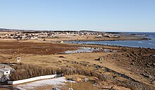
Vestbygd or Borhaug is a village in Farsund municipality in Agder county, Norway. The village is located on the southwestern shore of the Lista peninsula, about 6 kilometres (3.7 mi) straight west of the village of Vanse. The Farsund Airport, Lista is located on the east side of Vestbygd. The Lista Lighthouse lies just west of the village. The village has a small harbour, surrounded by a breakwater which protects it from the open North Sea. Vestbygda Chapel is located in the village. The fishing village once had a thriving boatbuilding business, but that is now closed.

The 0.9-square-kilometre (220-acre) village has a population (2015) of 1,123 which gives the village a population density of 1,248 inhabitants per square kilometre (3,230/sq mi).
References
- ^ Statistisk sentralbyrå (1 January 2015). "Urban settlements. Population and area, by municipality".
- "Vestbygd". yr.no. Retrieved 2016-09-29.
- Store norske leksikon. "Vestbygd" (in Norwegian). Retrieved 2016-09-29.
This Agder location article is a stub. You can help Misplaced Pages by expanding it. |